San Raymundo Jalpam geodata
San Raymundo Jalpam (Oaxaca) is a seat of a second-order administrative division; located in Mexico in America/Mexico_City (GMT-6) time zone. With population of 1,882 people, there are 4619 cities with bigger population in this country. Compared to other cities in Mexico, 89.3% of cities are located further ↑North; 77.8% of cities are located further ←West and 52.4% of cities have lower elevation than San Raymundo Jalpam. Note1


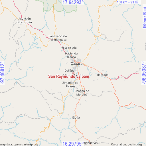
San Raymundo Jalpam GPS coordinates[2]
16° 58' 17.904" North, 96° 45' 25.164" West
| Map corner | latitude | longitude |
|---|---|---|
| Upper-left | 17.64293°, | -97.46012° |
| Center: | 16.97164°, | -96.75699° |
| Lower-right: | 16.29795°, | -96.05387° |
| Map W x H: | 149.5×149.6 km | = 92.9×93mi |
| max Lat: | 32.7° ⇑89.3% North |
| San Raymundo Jalpam: | 16.97164° |
| min Lat: | ⇓10.7% South 14.53588° |
| min Long | San Raymundo Ja | max Long |
| -117.105° | -96.75699° | -86.73105° |
| W 77.8%⇐ | ⇒22.2% E |
Elevation
Elevation of San Raymundo Jalpam is 1531 m = 5023 ft, and this is 277.3 m = 910 ft above average elevation for this country.
| Max E: |
3497 m = 11473 ft | 47.6% |
| San Raymundo Jalpam | 1531 m 5023 ft | |
| Avg. | 1253.7 m = 4113 ft | |
Min E: |
-1 m = -3 ft | 52.4% |
See also: Mexico elevation on elevation.city.
Geographical zone
San Raymundo Jalpam is located in North Torrid zone (between Equator and Tropic of Cancer). Distance of this Northern Tropic circle is 718.8 km =446.6 mi to North.| Distance of | km | miles | from San Raymundo Jalpam |
|---|---|---|---|
| North Pole | 8120 | 5045.5 | to North |
| Arctic Circle | 5514.1 | 3426.3 | to North |
| Tropic Cancer | 718.8 | 446.6 | to North |
| Equator | 1887.1 | 1172.6 | to South |


Nearby cities:
15 places around San Raymundo Jalpam: (largest is in red/bold)
• Animas Trujano
5.1 km =3.2 mi,  65°
65°
• Cruz Blanca
4.9 km =3 mi,  355°
355°
• Cuilapan de Guerrero
2.6 km =1.6 mi,  284°
284°
• Emiliano Zapata
5.9 km =3.7 mi,  133°
133°
• Fraccionamiento Real del Valle
4.5 km =2.8 mi,  194°
194°
• Lomas de San Juan
3.8 km =2.4 mi,  345°
345°
• San Agustin de las Juntas
6.3 km =3.9 mi,  55°
55°
• San Bartolo Coyotespec
5.3 km =3.3 mi,  106°
106°
• San Isidro Monjas
3.5 km =2.2 mi,  14°
14°
• San Juan Bautista la Raya
3.8 km =2.4 mi, 64°
• San Lucas Tlanichico
5.4 km =3.4 mi,  270°
270°
• San Miguel Tlanichico
4.9 km =3 mi,  213°
213°
• Santa María Coyotepec
5.5 km =3.4 mi,  95°
95°
• Trinidad Zaachila
5.6 km =3.5 mi, 187°
• Villa de Zaachila
2.4 km =1.5 mi,  160°
160°
Sources, notices
• [Note1] Compared only with cities in Mexico existing in our database
• [Src1] Map data: © OpenStreetMap contributors (CC-BY-SA)
• [Src2] Other city data from geonames.org with taken over terms of usage.
• [Src3] Geographical zone / Annual Mean Temperature by Robert A. Rohde @ Wikipedia
