Coíntzio geodata
Coíntzio (Michoacán) is a populated place; located in Mexico in America/Mexico_City (GMT-6) time zone. With population of 732 people, there are 11935 cities with bigger population in this country. Compared to other cities in Mexico, 51.1% of cities are located further ↑North; 75.4% of cities are located further →East and 69.8% of cities have lower elevation than Coíntzio. Note1


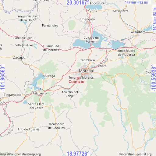
Coíntzio GPS coordinates[2]
19° 38' 26.988" North, 101° 15' 45" West
| Map corner | latitude | longitude |
|---|---|---|
| Upper-left | 20.30167°, | -101.96563° |
| Center: | 19.64083°, | -101.2625° |
| Lower-right: | 18.97726°, | -100.55938° |
| Map W x H: | 147.3×147.3 km | = 91.5×91.5mi |
| max Lat: | 32.7° ⇑51.1% North |
| Coíntzio: | 19.64083° |
| min Lat: | ⇓48.9% South 14.53588° |
| min Long | Coíntzio | max Long |
| -117.105° | -101.2625° | -86.73105° |
| W 24.6%⇐ | ⇒75.4% E |
Elevation
Elevation of Coíntzio is 1920 m = 6299 ft, and this is 666.3 m = 2186 ft above average elevation for this country.
| Max E: |
3497 m = 11473 ft | 30.2% |
| Coíntzio | 1920 m 6299 ft | |
| Avg. | 1253.7 m = 4113 ft | |
Min E: |
-1 m = -3 ft | 69.8% |
See also: Mexico elevation on elevation.city.
Geographical zone
Coíntzio is located in North Torrid zone (between Equator and Tropic of Cancer). Distance of this Northern Tropic circle is 422.1 km =262.3 mi to North.| Distance of | km | miles | from Coíntzio |
|---|---|---|---|
| North Pole | 7823.2 | 4861.1 | to North |
| Arctic Circle | 5217.3 | 3241.9 | to North |
| Tropic Cancer | 422.1 | 262.3 | to North |
| Equator | 2183.9 | 1357 | to South |


Nearby cities:
15 places around Coíntzio: (largest is in red/bold)
• Conjunto Habitacional Villas del Pedregal
6.4 km =4 mi,  317°
317°
• El Cerrito Itzícuaro
3.7 km =2.3 mi,  331°
331°
• Estación Jácuaro (Colonia la Reunión)
5.8 km =3.6 mi,  211°
211°
• Fraccionamiento San Lorenzo
4.7 km =2.9 mi,  344°
344°
• La Mintzita (Piedra Dura)
2 km =1.2 mi,  308°
308°
• Morelos
2.6 km =1.6 mi,  70°
70°
• San Antonio
3 km =1.9 mi,  348°
348°
• San Antonio Parangare
3.3 km =2.1 mi,  280°
280°
• San Juanito Itzícuaro
4 km =2.5 mi,  12°
12°
• San Lorenzo Itzícuaro
4.4 km =2.7 mi, 334°
• San Nicolás Obispo
5.7 km =3.5 mi, 283°
• Santiago Undameo
5.6 km =3.5 mi,  204°
204°
• Unión de Tabiqueros del Río Grande de Morelia
4.6 km =2.9 mi,  21°
21°
• Uruapilla
2.9 km =1.8 mi, 214°
• Villas de la Loma
6.7 km =4.2 mi, 324°
Sources, notices
• [Note1] Compared only with cities in Mexico existing in our database
• [Src1] Map data: © OpenStreetMap contributors (CC-BY-SA)
• [Src2] Other city data from geonames.org with taken over terms of usage.
• [Src3] Geographical zone / Annual Mean Temperature by Robert A. Rohde @ Wikipedia
