Uruapilla geodata
Uruapilla (Michoacán) is a populated place; located in Mexico in America/Mexico_City (GMT-6) time zone. With population of 713 people, there are 12219 cities with bigger population in this country. Compared to other cities in Mexico, 51.5% of cities are located further ↑North; 75.5% of cities are located further →East and 74.1% of cities have lower elevation than Uruapilla. Note1


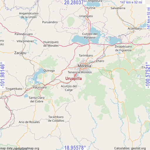
Uruapilla GPS coordinates[2]
19° 37' 9.984" North, 101° 16' 41.988" West
| Map corner | latitude | longitude |
|---|---|---|
| Upper-left | 20.28037°, | -101.98146° |
| Center: | 19.61944°, | -101.27833° |
| Lower-right: | 18.95578°, | -100.57521° |
| Map W x H: | 147.3×147.3 km | = 91.5×91.5mi |
| max Lat: | 32.7° ⇑51.5% North |
| Uruapilla: | 19.61944° |
| min Lat: | ⇓48.5% South 14.53588° |
| min Long | Uruapilla | max Long |
| -117.105° | -101.27833° | -86.73105° |
| W 24.5%⇐ | ⇒75.5% E |
Elevation
Elevation of Uruapilla is 2014 m = 6608 ft, and this is 760.3 m = 2494 ft above average elevation for this country.
| Max E: |
3497 m = 11473 ft | 25.9% |
| Uruapilla | 2014 m 6608 ft | |
| Avg. | 1253.7 m = 4113 ft | |
Min E: |
-1 m = -3 ft | 74.1% |
See also: Mexico elevation on elevation.city.
Geographical zone
Uruapilla is located in North Torrid zone (between Equator and Tropic of Cancer). Distance of this Northern Tropic circle is 424.4 km =263.7 mi to North.| Distance of | km | miles | from Uruapilla |
|---|---|---|---|
| North Pole | 7825.6 | 4862.6 | to North |
| Arctic Circle | 5219.7 | 3243.4 | to North |
| Tropic Cancer | 424.4 | 263.7 | to North |
| Equator | 2181.5 | 1355.5 | to South |


Nearby cities:
15 places around Uruapilla: (largest is in red/bold)
• Coíntzio
2.9 km =1.8 mi,  34°
34°
• El Cerrito Itzícuaro
5.6 km =3.5 mi,  359°
359°
• Estación Jácuaro (Colonia la Reunión)
3 km =1.9 mi,  207°
207°
• Fraccionamiento San Lorenzo
6.9 km =4.3 mi,  3°
3°
• La Estancia
4.6 km =2.9 mi,  221°
221°
• La Mintzita (Piedra Dura)
3.6 km =2.2 mi, 1°
• Morelos
5.3 km =3.3 mi,  51°
51°
• San Antonio
5.4 km =3.4 mi,  11°
11°
• San Antonio Parangare
3.3 km =2.1 mi,  332°
332°
• San Juanito Itzícuaro
6.7 km =4.2 mi,  21°
21°
• San Lorenzo Itzícuaro
6.4 km =4 mi, 357°
• San Nicolás Obispo
5.4 km =3.4 mi,  313°
313°
• Santiago Undameo
2.8 km =1.7 mi,  194°
194°
• Tirio
6.4 km =4 mi,  179°
179°
• Unión de Tabiqueros del Río Grande de Morelia
7.4 km =4.6 mi, 26°
Sources, notices
• [Note1] Compared only with cities in Mexico existing in our database
• [Src1] Map data: © OpenStreetMap contributors (CC-BY-SA)
• [Src2] Other city data from geonames.org with taken over terms of usage.
• [Src3] Geographical zone / Annual Mean Temperature by Robert A. Rohde @ Wikipedia
