San Juanito Itzícuaro geodata
San Juanito Itzícuaro (Michoacán) is a populated place; located in Mexico in America/Mexico_City (GMT-6) time zone. With population of 2,044 people, there are 4263 cities with bigger population in this country. Compared to other cities in Mexico, 50.3% of cities are located further ↑North; 75.3% of cities are located further →East and 68.8% of cities have lower elevation than San Juanito Itzícuaro. Note1
Current local time in San Juanito Itzícuaro:
05:34 AM, WednesdayDifference from your time zone: hours


San Juanito Itzícuaro GPS coordinates[2]
19° 40' 32.592" North, 101° 15' 16.452" West
| Map corner | latitude | longitude |
|---|---|---|
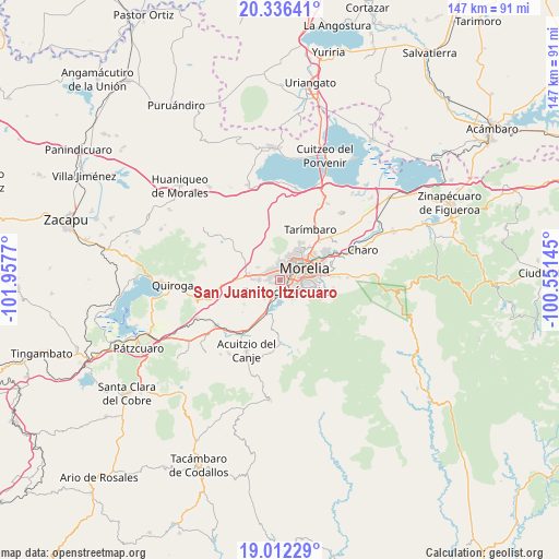
| Upper-left | 20.33641°, | -101.9577° |
| Center: | 19.67572°, | -101.25457° |
| Lower-right: | 19.01229°, | -100.55145° |
| Map W x H: | 147.2×147.2 km | = 91.5×91.5mi |
| max Lat: | 32.7° ⇑50.3% North |
| San Juanito Itzícuaro: | 19.67572° |
| min Lat: | ⇓49.7% South 14.53588° |
| min Long | San Juanito Itz | max Long |
| -117.105° | -101.25457° | -86.73105° |
| W 24.7%⇐ | ⇒75.3% E |
Elevation
Elevation of San Juanito Itzícuaro is 1903 m = 6243 ft, and this is 649.3 m = 2130 ft above average elevation for this country.
| Max E: |
3497 m = 11473 ft | 31.2% |
| San Juanito Itzícuaro | 1903 m 6243 ft | |
| Avg. | 1253.7 m = 4113 ft | |
Min E: |
-1 m = -3 ft | 68.8% |
See also: Mexico elevation on elevation.city.
Geographical zone
San Juanito Itzícuaro is located in North Torrid zone (between Equator and Tropic of Cancer). Distance of this Northern Tropic circle is 418.2 km =259.9 mi to North.| Distance of | km | miles | from San Juanito Itzícuaro |
|---|---|---|---|
| North Pole | 7819.3 | 4858.7 | to North |
| Arctic Circle | 5213.4 | 3239.5 | to North |
| Tropic Cancer | 418.2 | 259.9 | to North |
| Equator | 2187.7 | 1359.4 | to South |


Nearby cities:
15 places around San Juanito Itzícuaro: (largest is in red/bold)
• Conjunto Habitacional Villas del Pedregal
5.2 km =3.2 mi,  279°
279°
• Coíntzio
4 km =2.5 mi,  192°
192°
• El Cerrito Itzícuaro
2.6 km =1.6 mi,  255°
255°
• Fraccionamiento San Lorenzo
2.2 km =1.4 mi,  286°
286°
• La Concepción
6.7 km =4.2 mi,  298°
298°
• La Mintzita (Piedra Dura)
3.6 km =2.2 mi,  222°
222°
• Morelos
3.4 km =2.1 mi,  151°
151°
• San Antonio
1.7 km =1.1 mi,  236°
236°
• San Antonio Parangare
5.2 km =3.2 mi,  230°
230°
• San Lorenzo Itzícuaro
2.8 km =1.7 mi,  272°
272°
• San Nicolás Obispo
6.9 km =4.3 mi,  248°
248°
• Unión de Tabiqueros del Río Grande de Morelia
0.9 km =0.6 mi,  67°
67°
• Uruapilla
6.7 km =4.2 mi,  201°
201°
• Villa Magna
7.6 km =4.7 mi, 276°
• Villas de la Loma
5 km =3.1 mi, 288°
Sources, notices
• [Note1] Compared only with cities in Mexico existing in our database
• [Src1] Map data: © OpenStreetMap contributors (CC-BY-SA)
• [Src2] Other city data from geonames.org with taken over terms of usage.
• [Src3] Geographical zone / Annual Mean Temperature by Robert A. Rohde @ Wikipedia
