Veintidós de Febrero geodata
Veintidós de Febrero (State of Mexico) is a populated place; located in Mexico in America/Mexico_City (GMT-6) time zone. With population of 13,021 people, there are 754 cities with bigger population in this country. Compared to other cities in Mexico, 51.6% of cities are located further ↑North; 54.8% of cities are located further →East and 91.7% of cities have lower elevation than Veintidós de Febrero. Note1
Current local time in Veintidós de Febrero:
03:03 AM, WednesdayDifference from your time zone: hours


Veintidós de Febrero GPS coordinates[2]
19° 36' 41.004" North, 99° 20' 48.012" West
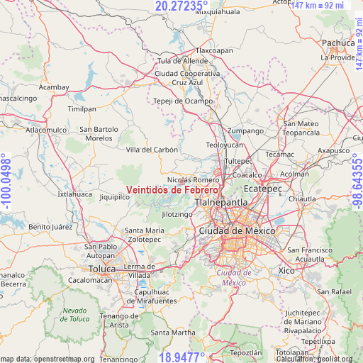
| Map corner | latitude | longitude |
|---|---|---|
| Upper-left | 20.27235°, | -100.0498° |
| Center: | 19.61139°, | -99.34667° |
| Lower-right: | 18.9477°, | -98.64355° |
| Map W x H: | 147.3×147.3 km | = 91.5×91.5mi |
| max Lat: | 32.7° ⇑51.6% North |
| Veintidós de Febrero: | 19.61139° |
| min Lat: | ⇓48.4% South 14.53588° |
| min Long | Veintidós de F | max Long |
| -117.105° | -99.34667° | -86.73105° |
| W 45.2%⇐ | ⇒54.8% E |
Elevation
Elevation of Veintidós de Febrero is 2469 m = 8100 ft, and this is 1215.3 m = 3987 ft above average elevation for this country.
| Max E: |
3497 m = 11473 ft | 8.3% |
| Veintidós de Febrero | 2469 m 8100 ft | |
| Avg. | 1253.7 m = 4113 ft | |
Min E: |
-1 m = -3 ft | 91.7% |
See also: Mexico elevation on elevation.city.
Geographical zone
Veintidós de Febrero is located in North Torrid zone (between Equator and Tropic of Cancer). Distance of this Northern Tropic circle is 425.3 km =264.3 mi to North.| Distance of | km | miles | from Veintidós de Febrero |
|---|---|---|---|
| North Pole | 7826.5 | 4863.2 | to North |
| Arctic Circle | 5220.6 | 3243.9 | to North |
| Tropic Cancer | 425.3 | 264.3 | to North |
| Equator | 2180.6 | 1355 | to South |


Nearby cities:
15 places around Veintidós de Febrero: (largest is in red/bold)
• Caja de Agua
4 km =2.5 mi,  331°
331°
• Cañada de Onofres
5.3 km =3.3 mi,  181°
181°
• Colonia Llano Grande (Nuevo Ejido)
1.9 km =1.2 mi,  233°
233°
• Colonia Morelos
3 km =1.9 mi,  14°
14°
• Ejido los Jarros
2.5 km =1.6 mi,  201°
201°
• Joya del Tejocote
3.4 km =2.1 mi,  354°
354°
• Loma Larga
1.8 km =1.1 mi,  1°
1°
• Loma de Chapultepec
6.8 km =4.2 mi,  272°
272°
• Loma de Guadalupe (La Biznaga)
5.1 km =3.2 mi, 333°
• Loma de San José
4 km =2.5 mi,  29°
29°
• Loma del Río
1.3 km =0.8 mi, 198°
• Nicolás Romero
5.4 km =3.4 mi,  51°
51°
• Progreso Industrial
3 km =1.9 mi,  338°
338°
• San José el Vidrio
6.1 km =3.8 mi,  319°
319°
• San Miguel Hila
3 km =1.9 mi,  131°
131°
Sources, notices
• [Note1] Compared only with cities in Mexico existing in our database
• [Src1] Map data: © OpenStreetMap contributors (CC-BY-SA)
• [Src2] Other city data from geonames.org with taken over terms of usage.
• [Src3] Geographical zone / Annual Mean Temperature by Robert A. Rohde @ Wikipedia
