Atoluca geodata
Atoluca (Puebla) is a populated place; located in Mexico in America/Mexico_City (GMT-6) time zone. With population of 5,187 people, there are 1787 cities with bigger population in this country. Compared to other cities in Mexico, 54.1% of cities are located further ↓South; 71% of cities are located further ←West and 62.1% of cities have lower elevation than Atoluca. Note1


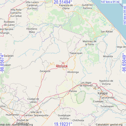
Atoluca GPS coordinates[2]
19° 51' 18" North, 97° 21' 12.996" West
| Map corner | latitude | longitude |
|---|---|---|
| Upper-left | 20.51494°, | -98.05674° |
| Center: | 19.855°, | -97.35361° |
| Lower-right: | 19.19231°, | -96.65049° |
| Map W x H: | 147.1×147.1 km | = 91.4×91.4mi |
| max Lat: | 32.7° ⇑45.9% North |
| Atoluca: | 19.855° |
| min Lat: | ⇓54.1% South 14.53588° |
| min Long | Atoluca | max Long |
| -117.105° | -97.35361° | -86.73105° |
| W 71%⇐ | ⇒29% E |
Elevation
Elevation of Atoluca is 1761 m = 5778 ft, and this is 507.3 m = 1664 ft above average elevation for this country.
| Max E: |
3497 m = 11473 ft | 37.9% |
| Atoluca | 1761 m 5778 ft | |
| Avg. | 1253.7 m = 4113 ft | |
Min E: |
-1 m = -3 ft | 62.1% |
See also: Mexico elevation on elevation.city.
Geographical zone
Atoluca is located in North Torrid zone (between Equator and Tropic of Cancer). Distance of this Northern Tropic circle is 398.2 km =247.4 mi to North.| Distance of | km | miles | from Atoluca |
|---|---|---|---|
| North Pole | 7799.4 | 4846.3 | to North |
| Arctic Circle | 5193.5 | 3227.1 | to North |
| Tropic Cancer | 398.2 | 247.4 | to North |
| Equator | 2207.7 | 1371.8 | to South |


Nearby cities:
15 places around Atoluca: (largest is in red/bold)
• Huehueymico
2.8 km =1.7 mi,  123°
123°
• Ixtahuiata (La Legua)
2.3 km =1.4 mi, 123°
• Ixticpan
4.6 km =2.9 mi,  168°
168°
• Ixtlahuaca
4 km =2.5 mi,  151°
151°
• Maxtaco
3.4 km =2.1 mi,  164°
164°
• Mexcalcuautla
4.2 km =2.6 mi,  287°
287°
• San Acateno
2.6 km =1.6 mi,  328°
328°
• San Diego
0.8 km =0.5 mi,  283°
283°
• San Juan Tezongo
1.6 km =1 mi,  223°
223°
• San Sebastián
1.8 km =1.1 mi,  270°
270°
• Tepepan
3.9 km =2.4 mi,  230°
230°
• Tequimila
4.6 km =2.9 mi, 219°
• Teziutlan
4.2 km =2.6 mi,  188°
188°
• Xoloateno
3.1 km =1.9 mi,  211°
211°
• Yopi
4.2 km =2.6 mi, 221°
Sources, notices
• [Note1] Compared only with cities in Mexico existing in our database
• [Src1] Map data: © OpenStreetMap contributors (CC-BY-SA)
• [Src2] Other city data from geonames.org with taken over terms of usage.
• [Src3] Geographical zone / Annual Mean Temperature by Robert A. Rohde @ Wikipedia
