Huehueymico geodata
Huehueymico (Puebla) is a populated place; located in Mexico in America/Mexico_City (GMT-6) time zone. With population of 884 people, there are 9870 cities with bigger population in this country. Compared to other cities in Mexico, 53.8% of cities are located further ↓South; 71.3% of cities are located further ←West and 60.3% of cities have lower elevation than Huehueymico. Note1


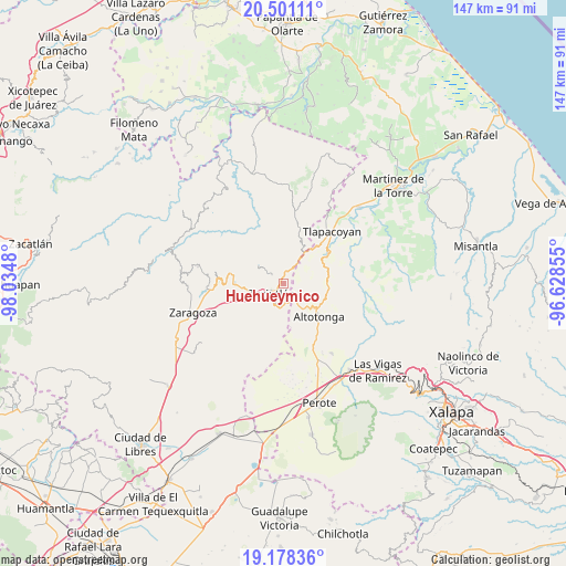
Huehueymico GPS coordinates[2]
19° 50' 27.996" North, 97° 19' 54.012" West
| Map corner | latitude | longitude |
|---|---|---|
| Upper-left | 20.50111°, | -98.0348° |
| Center: | 19.84111°, | -97.33167° |
| Lower-right: | 19.17836°, | -96.62855° |
| Map W x H: | 147.1×147.1 km | = 91.4×91.4mi |
| max Lat: | 32.7° ⇑46.2% North |
| Huehueymico: | 19.84111° |
| min Lat: | ⇓53.8% South 14.53588° |
| min Long | Huehueymico | max Long |
| -117.105° | -97.33167° | -86.73105° |
| W 71.3%⇐ | ⇒28.7% E |
Elevation
Elevation of Huehueymico is 1730 m = 5676 ft, and this is 476.3 m = 1563 ft above average elevation for this country.
| Max E: |
3497 m = 11473 ft | 39.7% |
| Huehueymico | 1730 m 5676 ft | |
| Avg. | 1253.7 m = 4113 ft | |
Min E: |
-1 m = -3 ft | 60.3% |
See also: Mexico elevation on elevation.city.
Geographical zone
Huehueymico is located in North Torrid zone (between Equator and Tropic of Cancer). Distance of this Northern Tropic circle is 399.8 km =248.4 mi to North.| Distance of | km | miles | from Huehueymico |
|---|---|---|---|
| North Pole | 7800.9 | 4847.3 | to North |
| Arctic Circle | 5195 | 3228 | to North |
| Tropic Cancer | 399.8 | 248.4 | to North |
| Equator | 2206.1 | 1370.8 | to South |


Nearby cities:
15 places around Huehueymico: (largest is in red/bold)
• Atoluca
2.8 km =1.7 mi,  303°
303°
• Cuaxoxpan
4 km =2.5 mi,  201°
201°
• Ejido Hueytamalco
4.2 km =2.6 mi,  27°
27°
• Ixtahuiata (La Legua)
0.5 km =0.3 mi,  307°
307°
• Ixticpan
3.3 km =2.1 mi, 204°
• Ixtlahuaca
2 km =1.2 mi,  189°
189°
• Maxtaco
2.2 km =1.4 mi,  219°
219°
• Melchor Ocampo
2.6 km =1.6 mi,  93°
93°
• San Diego
3.5 km =2.2 mi, 299°
• San José
4.2 km =2.6 mi,  183°
183°
• San Juan Tezongo
3.4 km =2.1 mi,  276°
276°
• San Salvador (Naranjillo)
2.1 km =1.3 mi,  121°
121°
• Santiago
3.4 km =2.1 mi,  165°
165°
• Teziutlan
4 km =2.5 mi,  228°
228°
• Xoloateno
4.1 km =2.5 mi,  254°
254°
Sources, notices
• [Note1] Compared only with cities in Mexico existing in our database
• [Src1] Map data: © OpenStreetMap contributors (CC-BY-SA)
• [Src2] Other city data from geonames.org with taken over terms of usage.
• [Src3] Geographical zone / Annual Mean Temperature by Robert A. Rohde @ Wikipedia
