Iquinuapa geodata
Iquinuapa (Tabasco) is a populated place; located in Mexico in America/Mexico_City (GMT-6) time zone. With population of 2,915 people, there are 3054 cities with bigger population in this country. Compared to other cities in Mexico, 76.3% of cities are located further ↑North; 88% of cities are located further ←West and 98.7% of cities have higher elevation than Iquinuapa. Note1


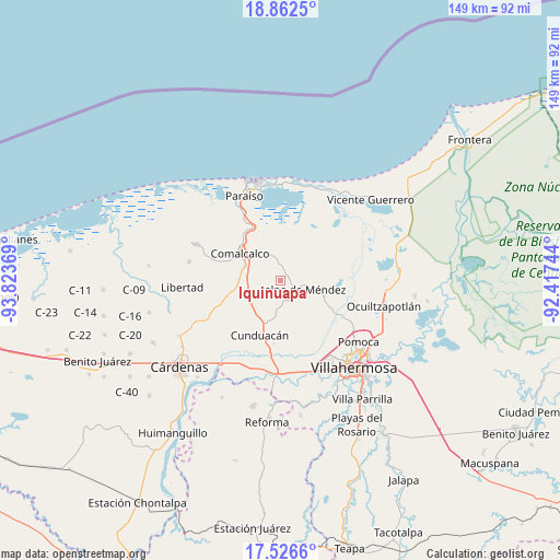
Iquinuapa GPS coordinates[2]
18° 11' 44.988" North, 93° 7' 14.016" West
| Map corner | latitude | longitude |
|---|---|---|
| Upper-left | 18.8625°, | -93.82369° |
| Center: | 18.19583°, | -93.12056° |
| Lower-right: | 17.5266°, | -92.41744° |
| Map W x H: | 148.5×148.5 km | = 92.3×92.3mi |
| max Lat: | 32.7° ⇑76.3% North |
| Iquinuapa: | 18.19583° |
| min Lat: | ⇓23.7% South 14.53588° |
| min Long | Iquinuapa | max Long |
| -117.105° | -93.12056° | -86.73105° |
| W 88%⇐ | ⇒12% E |
Elevation
Elevation of Iquinuapa is 7 m = 23 ft, and this is 1246.7 m = 4090 ft below average elevation for this country.
| Max E: |
3497 m = 11473 ft | 98.7% |
| Avg. | 1253.7 m = 4113 ft | |
| Iquinuapa | 7 m = 23 ft | |
Min E: |
-1 m = -3 ft | 1.3% |
See also: Mexico elevation on elevation.city.
Geographical zone
Iquinuapa is located in North Torrid zone (between Equator and Tropic of Cancer). Distance of this Northern Tropic circle is 582.7 km =362.1 mi to North.| Distance of | km | miles | from Iquinuapa |
|---|---|---|---|
| North Pole | 7983.9 | 4961 | to North |
| Arctic Circle | 5378 | 3341.7 | to North |
| Tropic Cancer | 582.7 | 362.1 | to North |
| Equator | 2023.2 | 1257.2 | to South |


Nearby cities:
15 places around Iquinuapa: (largest is in red/bold)
• Ayapa
3.3 km =2.1 mi,  16°
16°
• Boquiapa
4.3 km =2.7 mi,  204°
204°
• Cupilco
4.9 km =3 mi,  351°
351°
• Cúlico 2da. Sección
6.2 km =3.9 mi,  191°
191°
• El Carmen
3.9 km =2.4 mi,  302°
302°
• Gregorio Méndez
1.9 km =1.2 mi,  88°
88°
• Hermenegildo Galeana 2da. Sección
3.2 km =2 mi,  208°
208°
• Huapacal 2da. Sección (Punta Brava)
5.4 km =3.4 mi,  271°
271°
• La Ensenada
4.8 km =3 mi,  44°
44°
• La Pera
3.5 km =2.2 mi,  180°
180°
• Nicolás Bravo
6 km =3.7 mi,  138°
138°
• Novillero 4ta. Sección
5.5 km =3.4 mi,  6°
6°
• Pueblo Viejo
3.7 km =2.3 mi,  83°
83°
• Soyataco
5.1 km =3.2 mi,  72°
72°
• Uspí
6 km =3.7 mi,  356°
356°
Sources, notices
• [Note1] Compared only with cities in Mexico existing in our database
• [Src1] Map data: © OpenStreetMap contributors (CC-BY-SA)
• [Src2] Other city data from geonames.org with taken over terms of usage.
• [Src3] Geographical zone / Annual Mean Temperature by Robert A. Rohde @ Wikipedia
