Tuncingo geodata
Tuncingo (Guerrero) is a populated place; located in Mexico in America/Mexico_City (GMT-6) time zone. With population of 2,570 people, there are 3445 cities with bigger population in this country. Compared to other cities in Mexico, 91% of cities are located further ↑North; 61.3% of cities are located further →East and 83.6% of cities have higher elevation than Tuncingo. Note1


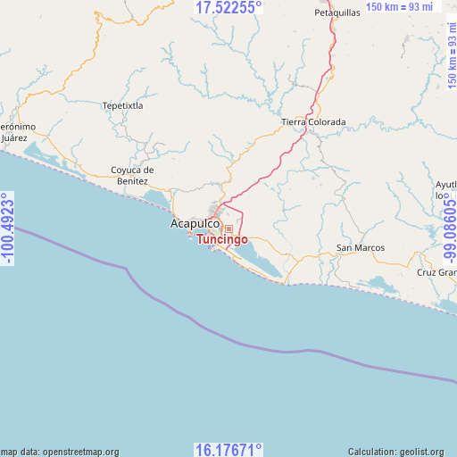
Tuncingo GPS coordinates[2]
16° 51' 2.988" North, 99° 47' 21.012" West
| Map corner | latitude | longitude |
|---|---|---|
| Upper-left | 17.52255°, | -100.4923° |
| Center: | 16.85083°, | -99.78917° |
| Lower-right: | 16.17671°, | -99.08605° |
| Map W x H: | 149.6×149.6 km | = 93×93mi |
| max Lat: | 32.7° ⇑91% North |
| Tuncingo: | 16.85083° |
| min Lat: | ⇓9% South 14.53588° |
| min Long | Tuncingo | max Long |
| -117.105° | -99.78917° | -86.73105° |
| W 38.7%⇐ | ⇒61.3% E |
Elevation
Elevation of Tuncingo is 54 m = 177 ft, and this is 1199.7 m = 3936 ft below average elevation for this country.
| Max E: |
3497 m = 11473 ft | 83.6% |
| Avg. | 1253.7 m = 4113 ft | |
| Tuncingo | 54 m = 177 ft | |
Min E: |
-1 m = -3 ft | 16.4% |
See also: Mexico elevation on elevation.city.
Geographical zone
Tuncingo is located in North Torrid zone (between Equator and Tropic of Cancer). Distance of this Northern Tropic circle is 732.3 km =455 mi to North.| Distance of | km | miles | from Tuncingo |
|---|---|---|---|
| North Pole | 8133.4 | 5053.9 | to North |
| Arctic Circle | 5527.5 | 3434.6 | to North |
| Tropic Cancer | 732.3 | 455 | to North |
| Equator | 1873.6 | 1164.2 | to South |


Nearby cities:
15 places around Tuncingo: (largest is in red/bold)
• 10 de Abril
5.7 km =3.5 mi,  115°
115°
• Colonia Alborada
4.6 km =2.9 mi,  318°
318°
• Colonia Loma Larga (El Basurero)
9.5 km =5.9 mi,  303°
303°
• Colonia Mangos (El Quemado)
9.3 km =5.8 mi,  338°
338°
• Colonia Miguel Terrazas Rivera
4.7 km =2.9 mi,  328°
328°
• Colonia Nueva Revolución
5.6 km =3.5 mi, 341°
• El Bejuco
9.2 km =5.7 mi,  108°
108°
• El Metlapil
4.4 km =2.7 mi,  103°
103°
• El Salto
3 km =1.9 mi,  58°
58°
• Las Plazuelas
2.6 km =1.6 mi,  8°
8°
• Nicolás Bravo (Zanja del Teniente)
4.9 km =3 mi, 114°
• Nueva Frontera
5 km =3.1 mi, 325°
• San Isidro Gallinero (El Gallinero)
8.7 km =5.4 mi,  66°
66°
• San Pedro las Playas
6.9 km =4.3 mi, 116°
• Tres Palos
2.6 km =1.6 mi,  153°
153°
Sources, notices
• [Note1] Compared only with cities in Mexico existing in our database
• [Src1] Map data: © OpenStreetMap contributors (CC-BY-SA)
• [Src2] Other city data from geonames.org with taken over terms of usage.
• [Src3] Geographical zone / Annual Mean Temperature by Robert A. Rohde @ Wikipedia
