Kotolte geodata
Kotolte (Chiapas) is a populated place; located in Mexico in America/Mexico_City (GMT-6) time zone. With population of 2,503 people, there are 3528 cities with bigger population in this country. Compared to other cities in Mexico, 90.9% of cities are located further ↑North; 92.2% of cities are located further ←West and 51% of cities have lower elevation than Kotolte. Note1


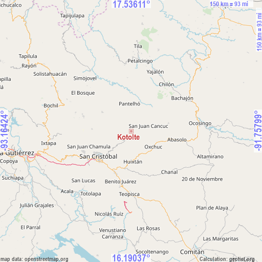
Kotolte GPS coordinates[2]
16° 51' 51.984" North, 92° 27' 39.996" West
| Map corner | latitude | longitude |
|---|---|---|
| Upper-left | 17.53611°, | -93.16424° |
| Center: | 16.86444°, | -92.46111° |
| Lower-right: | 16.19037°, | -91.75799° |
| Map W x H: | 149.6×149.6 km | = 93×93mi |
| max Lat: | 32.7° ⇑90.9% North |
| Kotolte: | 16.86444° |
| min Lat: | ⇓9.1% South 14.53588° |
| min Long | Kotolte | max Long |
| -117.105° | -92.46111° | -86.73105° |
| W 92.2%⇐ | ⇒7.8% E |
Elevation
Elevation of Kotolte is 1485 m = 4872 ft, and this is 231.3 m = 759 ft above average elevation for this country.
| Max E: |
3497 m = 11473 ft | 49% |
| Kotolte | 1485 m 4872 ft | |
| Avg. | 1253.7 m = 4113 ft | |
Min E: |
-1 m = -3 ft | 51% |
See also: Mexico elevation on elevation.city.
Geographical zone
Kotolte is located in North Torrid zone (between Equator and Tropic of Cancer). Distance of this Northern Tropic circle is 730.8 km =454.1 mi to North.| Distance of | km | miles | from Kotolte |
|---|---|---|---|
| North Pole | 8131.9 | 5052.9 | to North |
| Arctic Circle | 5526 | 3433.7 | to North |
| Tropic Cancer | 730.8 | 454.1 | to North |
| Equator | 1875.1 | 1165.1 | to South |


Nearby cities:
15 places around Kotolte: (largest is in red/bold)
• Chacoma
3.5 km =2.2 mi,  291°
291°
• Chana
2.9 km =1.8 mi,  322°
322°
• Chixtontic
3 km =1.9 mi,  6°
6°
• Jerusalén
2.7 km =1.7 mi,  196°
196°
• Juxalja
3.6 km =2.2 mi,  357°
357°
• Kulaktik
1.7 km =1.1 mi,  305°
305°
• Nailchén
3 km =1.9 mi,  73°
73°
• Ococh
3.3 km =2.1 mi,  207°
207°
• Shishintonil
3.1 km =1.9 mi,  234°
234°
• Sibaniljá Pocolum
1.3 km =0.8 mi,  0°
0°
• Tz'Aquiviljok
1 km =0.6 mi,  171°
171°
• Tzajalchén
2.5 km =1.6 mi,  177°
177°
• Yashanal
4.1 km =2.5 mi, 166°
• Yetzucum
2.9 km =1.8 mi,  40°
40°
• Yoshib
2.7 km =1.7 mi,  143°
143°
Sources, notices
• [Note1] Compared only with cities in Mexico existing in our database
• [Src1] Map data: © OpenStreetMap contributors (CC-BY-SA)
• [Src2] Other city data from geonames.org with taken over terms of usage.
• [Src3] Geographical zone / Annual Mean Temperature by Robert A. Rohde @ Wikipedia
