Chixtontic geodata
Chixtontic (Chiapas) is a populated place; located in Mexico in America/Mexico_City (GMT-6) time zone. With population of 1,512 people, there are 5705 cities with bigger population in this country. Compared to other cities in Mexico, 90.4% of cities are located further ↑North; 92.2% of cities are located further ←West and 50.4% of cities have higher elevation than Chixtontic. Note1


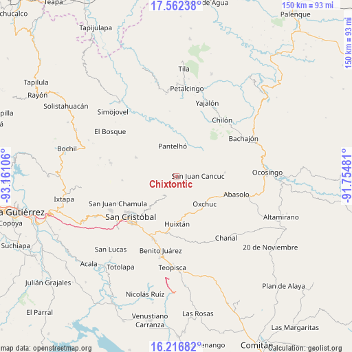
Chixtontic GPS coordinates[2]
16° 53' 26.88" North, 92° 27' 28.548" West
| Map corner | latitude | longitude |
|---|---|---|
| Upper-left | 17.56238°, | -93.16106° |
| Center: | 16.8908°, | -92.45793° |
| Lower-right: | 16.21682°, | -91.75481° |
| Map W x H: | 149.6×149.6 km | = 93×93mi |
| max Lat: | 32.7° ⇑90.4% North |
| Chixtontic: | 16.8908° |
| min Lat: | ⇓9.6% South 14.53588° |
| min Long | Chixtontic | max Long |
| -117.105° | -92.45793° | -86.73105° |
| W 92.2%⇐ | ⇒7.8% E |
Elevation
Elevation of Chixtontic is 1410 m = 4626 ft, and this is 156.3 m = 513 ft above average elevation for this country.
| Max E: |
3497 m = 11473 ft | 50.4% |
| Chixtontic | 1410 m 4626 ft | |
| Avg. | 1253.7 m = 4113 ft | |
Min E: |
-1 m = -3 ft | 49.6% |
See also: Mexico elevation on elevation.city.
Geographical zone
Chixtontic is located in North Torrid zone (between Equator and Tropic of Cancer). Distance of this Northern Tropic circle is 727.8 km =452.2 mi to North.| Distance of | km | miles | from Chixtontic |
|---|---|---|---|
| North Pole | 8129 | 5051.1 | to North |
| Arctic Circle | 5523.1 | 3431.9 | to North |
| Tropic Cancer | 727.8 | 452.2 | to North |
| Equator | 1878.1 | 1167 | to South |


Nearby cities:
15 places around Chixtontic: (largest is in red/bold)
• Amaquil (Patio Amplio)
3.4 km =2.1 mi,  8°
8°
• Cancuc
3.9 km =2.4 mi,  316°
316°
• Chacoma
3.9 km =2.4 mi,  245°
245°
• Chana
2.2 km =1.4 mi, 252°
• Chiloljá
3.6 km =2.2 mi,  99°
99°
• Cruz Pilar
2.2 km =1.4 mi,  26°
26°
• Jomanichim
1.9 km =1.2 mi,  305°
305°
• Juxalja
0.9 km =0.6 mi, 324°
• Kotolte
3 km =1.9 mi,  186°
186°
• Kulaktik
2.6 km =1.6 mi,  222°
222°
• Nailchén
3.3 km =2.1 mi,  129°
129°
• Pactetón
2.8 km =1.7 mi,  301°
301°
• Sibaniljá Pocolum
1.6 km =1 mi, 191°
• Tres Cerros
3.2 km =2 mi,  330°
330°
• Yetzucum
1.7 km =1.1 mi,  115°
115°
Sources, notices
• [Note1] Compared only with cities in Mexico existing in our database
• [Src1] Map data: © OpenStreetMap contributors (CC-BY-SA)
• [Src2] Other city data from geonames.org with taken over terms of usage.
• [Src3] Geographical zone / Annual Mean Temperature by Robert A. Rohde @ Wikipedia
