Tlalnepantla geodata
Tlalnepantla (San Luis Potosí) is a populated place; located in Mexico in America/Mexico_City (GMT-6) time zone. With population of 2,478 people, there are 3569 cities with bigger population in this country. Compared to other cities in Mexico, 78.9% of cities are located further ↓South; 52.9% of cities are located further ←West and 70.8% of cities have higher elevation than Tlalnepantla. Note1


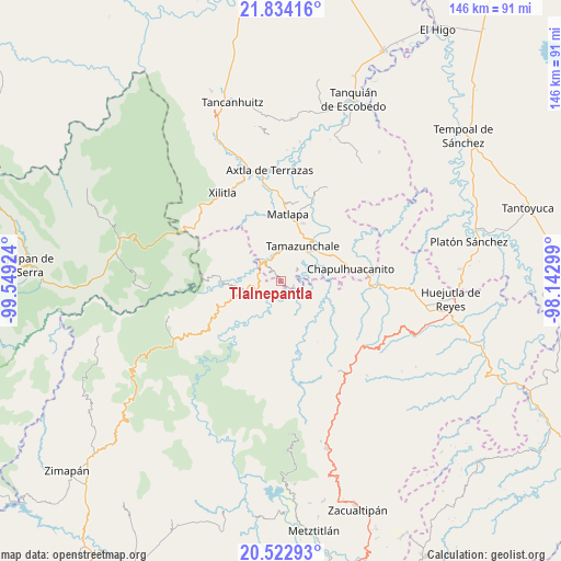
Tlalnepantla GPS coordinates[2]
21° 10' 48" North, 98° 50' 45.996" West
| Map corner | latitude | longitude |
|---|---|---|
| Upper-left | 21.83416°, | -99.54924° |
| Center: | 21.18°, | -98.84611° |
| Lower-right: | 20.52293°, | -98.14299° |
| Map W x H: | 145.8×145.8 km | = 90.6×90.6mi |
| max Lat: | 32.7° ⇑21.1% North |
| Tlalnepantla: | 21.18° |
| min Lat: | ⇓78.9% South 14.53588° |
| min Long | Tlalnepantla | max Long |
| -117.105° | -98.84611° | -86.73105° |
| W 52.9%⇐ | ⇒47.1% E |
Elevation
Elevation of Tlalnepantla is 377 m = 1237 ft, and this is 876.7 m = 2876 ft below average elevation for this country.
| Max E: |
3497 m = 11473 ft | 70.8% |
| Avg. | 1253.7 m = 4113 ft | |
| Tlalnepantla | 377 m = 1237 ft | |
Min E: |
-1 m = -3 ft | 29.2% |
See also: Mexico elevation on elevation.city.
Geographical zone
Tlalnepantla is located in North Torrid zone (between Equator and Tropic of Cancer). Distance of this Northern Tropic circle is 250.9 km =155.9 mi to North.| Distance of | km | miles | from Tlalnepantla |
|---|---|---|---|
| North Pole | 7652.1 | 4754.8 | to North |
| Arctic Circle | 5046.2 | 3135.6 | to North |
| Tropic Cancer | 250.9 | 155.9 | to North |
| Equator | 2355 | 1463.3 | to South |


Nearby cities:
15 places around Tlalnepantla: (largest is in red/bold)
• Amatitla Santiago
4.6 km =2.9 mi,  343°
343°
• Barrio Progreso
4.1 km =2.5 mi,  322°
322°
• Cahuazas
4.5 km =2.8 mi,  191°
191°
• Cahuazaz de Morelos (Rancho Alegre)
3.1 km =1.9 mi,  165°
165°
• El Carrizal
1.3 km =0.8 mi,  52°
52°
• Enramaditas
4.7 km =2.9 mi,  58°
58°
• Guaxcuaco
4.3 km =2.7 mi,  307°
307°
• Ixtla (Ixtla Santiago)
2.6 km =1.6 mi, 340°
• Papatlaco Santiago
5.1 km =3.2 mi,  4°
4°
• Pemucho
2.5 km =1.6 mi,  40°
40°
• Santiago Centro
3.3 km =2.1 mi,  327°
327°
• Tetitla
3.7 km =2.3 mi,  22°
22°
• Tezapotla
3.6 km =2.2 mi,  101°
101°
• Tixcuayuca
3.6 km =2.2 mi,  83°
83°
• Tlachiquilillacapa
1 km =0.6 mi,  141°
141°
Sources, notices
• [Note1] Compared only with cities in Mexico existing in our database
• [Src1] Map data: © OpenStreetMap contributors (CC-BY-SA)
• [Src2] Other city data from geonames.org with taken over terms of usage.
• [Src3] Geographical zone / Annual Mean Temperature by Robert A. Rohde @ Wikipedia
