Cahuazas geodata
Cahuazas (Hidalgo) is a populated place; located in Mexico in America/Mexico_City (GMT-6) time zone. With population of 705 people, there are 12337 cities with bigger population in this country. Compared to other cities in Mexico, 78.4% of cities are located further ↓South; 52.7% of cities are located further ←West and 72.6% of cities have higher elevation than Cahuazas. Note1


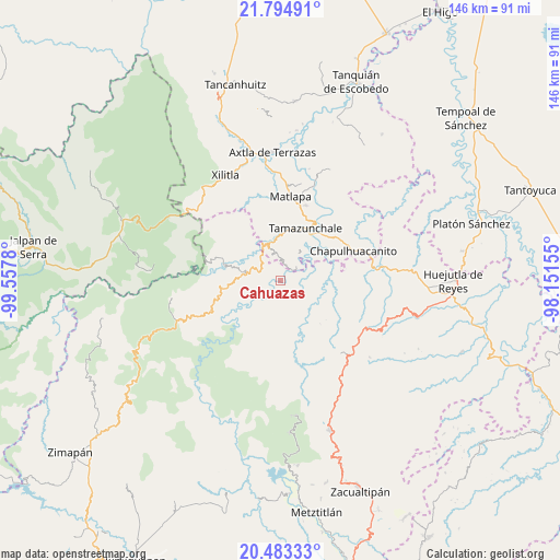
Cahuazas GPS coordinates[2]
21° 8' 26.052" North, 98° 51' 16.812" West
| Map corner | latitude | longitude |
|---|---|---|
| Upper-left | 21.79491°, | -99.5578° |
| Center: | 21.14057°, | -98.85467° |
| Lower-right: | 20.48333°, | -98.15155° |
| Map W x H: | 145.8×145.8 km | = 90.6×90.6mi |
| max Lat: | 32.7° ⇑21.6% North |
| Cahuazas: | 21.14057° |
| min Lat: | ⇓78.4% South 14.53588° |
| min Long | Cahuazas | max Long |
| -117.105° | -98.85467° | -86.73105° |
| W 52.7%⇐ | ⇒47.3% E |
Elevation
Elevation of Cahuazas is 307 m = 1007 ft, and this is 946.7 m = 3106 ft below average elevation for this country.
| Max E: |
3497 m = 11473 ft | 72.6% |
| Avg. | 1253.7 m = 4113 ft | |
| Cahuazas | 307 m = 1007 ft | |
Min E: |
-1 m = -3 ft | 27.4% |
See also: Mexico elevation on elevation.city.
Geographical zone
Cahuazas is located in North Torrid zone (between Equator and Tropic of Cancer). Distance of this Northern Tropic circle is 255.3 km =158.6 mi to North.| Distance of | km | miles | from Cahuazas |
|---|---|---|---|
| North Pole | 7656.5 | 4757.5 | to North |
| Arctic Circle | 5050.6 | 3138.3 | to North |
| Tropic Cancer | 255.3 | 158.6 | to North |
| Equator | 2350.6 | 1460.6 | to South |


Nearby cities:
15 places around Cahuazas: (largest is in red/bold)
• Cahuazaz de Morelos (Rancho Alegre)
2.1 km =1.3 mi,  49°
49°
• Chahuatitla
2.7 km =1.7 mi,  152°
152°
• Chapulhuacán
5.4 km =3.4 mi,  290°
290°
• Cuatolol
3.8 km =2.4 mi,  127°
127°
• El Carrizal
5.5 km =3.4 mi,  20°
20°
• Guaxcuaco
7.5 km =4.7 mi,  339°
339°
• Ixtla (Ixtla Santiago)
6.9 km =4.3 mi,  359°
359°
• Pemucho
6.8 km =4.2 mi, 21°
• Santiago Centro
7.3 km =4.5 mi,  352°
352°
• Texcapa
5.4 km =3.4 mi,  179°
179°
• Tezapotla
5.7 km =3.5 mi, 49°
• Tixcuayuca
6.6 km =4.1 mi,  42°
42°
• Tlachiquilillacapa
3.9 km =2.4 mi, 22°
• Tlalnepantla
4.5 km =2.8 mi,  11°
11°
• Zacualtipanito
5.9 km =3.7 mi,  75°
75°
Sources, notices
• [Note1] Compared only with cities in Mexico existing in our database
• [Src1] Map data: © OpenStreetMap contributors (CC-BY-SA)
• [Src2] Other city data from geonames.org with taken over terms of usage.
• [Src3] Geographical zone / Annual Mean Temperature by Robert A. Rohde @ Wikipedia
