Tatauzoquico geodata
Tatauzoquico (Puebla) is a populated place; located in Mexico in America/Mexico_City (GMT-6) time zone. With population of 1,970 people, there are 4425 cities with bigger population in this country. Compared to other cities in Mexico, 53.5% of cities are located further ↓South; 69.3% of cities are located further ←West and 78.3% of cities have lower elevation than Tatauzoquico. Note1


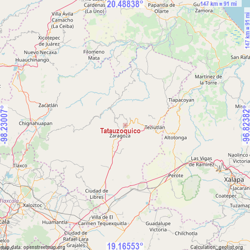
Tatauzoquico GPS coordinates[2]
19° 49' 41.988" North, 97° 31' 36.984" West
| Map corner | latitude | longitude |
|---|---|---|
| Upper-left | 20.48838°, | -98.23007° |
| Center: | 19.82833°, | -97.52694° |
| Lower-right: | 19.16553°, | -96.82382° |
| Map W x H: | 147.1×147.1 km | = 91.4×91.4mi |
| max Lat: | 32.7° ⇑46.5% North |
| Tatauzoquico: | 19.82833° |
| min Lat: | ⇓53.5% South 14.53588° |
| min Long | Tatauzoquico | max Long |
| -117.105° | -97.52694° | -86.73105° |
| W 69.3%⇐ | ⇒30.7% E |
Elevation
Elevation of Tatauzoquico is 2096 m = 6877 ft, and this is 842.3 m = 2763 ft above average elevation for this country.
| Max E: |
3497 m = 11473 ft | 21.7% |
| Tatauzoquico | 2096 m 6877 ft | |
| Avg. | 1253.7 m = 4113 ft | |
Min E: |
-1 m = -3 ft | 78.3% |
See also: Mexico elevation on elevation.city.
Geographical zone
Tatauzoquico is located in North Torrid zone (between Equator and Tropic of Cancer). Distance of this Northern Tropic circle is 401.2 km =249.3 mi to North.| Distance of | km | miles | from Tatauzoquico |
|---|---|---|---|
| North Pole | 7802.4 | 4848.2 | to North |
| Arctic Circle | 5196.5 | 3229 | to North |
| Tropic Cancer | 401.2 | 249.3 | to North |
| Equator | 2204.7 | 1369.9 | to South |


Nearby cities:
15 places around Tatauzoquico: (largest is in red/bold)
• Atalpa
3.7 km =2.3 mi,  40°
40°
• Atalpan
3.9 km =2.4 mi,  296°
296°
• Ciudad de Tlatlauquitepec
4.3 km =2.7 mi,  50°
50°
• Cuacuilco
3.1 km =1.9 mi,  325°
325°
• El Mirador
1.2 km =0.7 mi,  109°
109°
• Huaxtla
3.1 km =1.9 mi, 50°
• Nexticapan
2.9 km =1.8 mi,  267°
267°
• Ocota
3.3 km =2.1 mi, 107°
• Ocotlán de Betancourt
3.6 km =2.2 mi,  196°
196°
• Plan de Guadalupe
3.5 km =2.2 mi,  225°
225°
• Tatzecuala
4.7 km =2.9 mi,  346°
346°
• Tlatlauquitepec
3.8 km =2.4 mi,  55°
55°
• Tochimpa
2.2 km =1.4 mi,  87°
87°
• Tzinacantepec
3.5 km =2.2 mi, 114°
• Xonocuautla
4.5 km =2.8 mi,  165°
165°
Sources, notices
• [Note1] Compared only with cities in Mexico existing in our database
• [Src1] Map data: © OpenStreetMap contributors (CC-BY-SA)
• [Src2] Other city data from geonames.org with taken over terms of usage.
• [Src3] Geographical zone / Annual Mean Temperature by Robert A. Rohde @ Wikipedia
