Cuacuilco geodata
Cuacuilco (Puebla) is a populated place; located in Mexico in America/Mexico_City (GMT-6) time zone. With population of 577 people, there are 14851 cities with bigger population in this country. Compared to other cities in Mexico, 54.1% of cities are located further ↓South; 69.1% of cities are located further ←West and 87.1% of cities have lower elevation than Cuacuilco. Note1


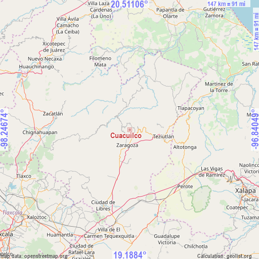
Cuacuilco GPS coordinates[2]
19° 51' 3.996" North, 97° 32' 36.996" West
| Map corner | latitude | longitude |
|---|---|---|
| Upper-left | 20.51106°, | -98.24674° |
| Center: | 19.85111°, | -97.54361° |
| Lower-right: | 19.1884°, | -96.84049° |
| Map W x H: | 147.1×147.1 km | = 91.4×91.4mi |
| max Lat: | 32.7° ⇑45.9% North |
| Cuacuilco: | 19.85111° |
| min Lat: | ⇓54.1% South 14.53588° |
| min Long | Cuacuilco | max Long |
| -117.105° | -97.54361° | -86.73105° |
| W 69.1%⇐ | ⇒30.9% E |
Elevation
Elevation of Cuacuilco is 2312 m = 7585 ft, and this is 1058.3 m = 3472 ft above average elevation for this country.
| Max E: |
3497 m = 11473 ft | 12.9% |
| Cuacuilco | 2312 m 7585 ft | |
| Avg. | 1253.7 m = 4113 ft | |
Min E: |
-1 m = -3 ft | 87.1% |
See also: Mexico elevation on elevation.city.
Geographical zone
Cuacuilco is located in North Torrid zone (between Equator and Tropic of Cancer). Distance of this Northern Tropic circle is 398.7 km =247.7 mi to North.| Distance of | km | miles | from Cuacuilco |
|---|---|---|---|
| North Pole | 7799.8 | 4846.6 | to North |
| Arctic Circle | 5193.9 | 3227.3 | to North |
| Tropic Cancer | 398.7 | 247.7 | to North |
| Equator | 2207.2 | 1371.5 | to South |


Nearby cities:
15 places around Cuacuilco: (largest is in red/bold)
• Ahuacatlán
3.5 km =2.2 mi,  357°
357°
• Atalpa
4.2 km =2.6 mi,  86°
86°
• Atalpan
1.9 km =1.2 mi,  244°
244°
• Ciudad de Tlatlauquitepec
5.1 km =3.2 mi, 87°
• El Mirador
4.1 km =2.5 mi,  135°
135°
• El Progreso
5.1 km =3.2 mi,  0°
0°
• Huaxtla
4.2 km =2.6 mi,  97°
97°
• Nexticapan
2.9 km =1.8 mi,  202°
202°
• Plan de Guadalupe
5.1 km =3.2 mi,  188°
188°
• Santa Cruz Xaltetela
4.7 km =2.9 mi,  303°
303°
• Tatauzoquico
3.1 km =1.9 mi,  145°
145°
• Tatoxcac
3.7 km =2.3 mi, 303°
• Tatzecuala
2.1 km =1.3 mi,  18°
18°
• Tlatlauquitepec
4.9 km =3 mi, 94°
• Tochimpa
4.6 km =2.9 mi,  121°
121°
Sources, notices
• [Note1] Compared only with cities in Mexico existing in our database
• [Src1] Map data: © OpenStreetMap contributors (CC-BY-SA)
• [Src2] Other city data from geonames.org with taken over terms of usage.
• [Src3] Geographical zone / Annual Mean Temperature by Robert A. Rohde @ Wikipedia
