El Jacal geodata
El Jacal (State of Mexico) is a populated place; located in Mexico in America/Mexico_City (GMT-6) time zone. With population of 1,928 people, there are 4510 cities with bigger population in this country. Compared to other cities in Mexico, 56.2% of cities are located further ↑North; 65% of cities are located further →East and 92.4% of cities have lower elevation than El Jacal. Note1


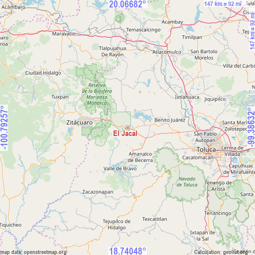
El Jacal GPS coordinates[2]
19° 24' 18" North, 100° 5' 21.984" West
| Map corner | latitude | longitude |
|---|---|---|
| Upper-left | 20.06682°, | -100.79257° |
| Center: | 19.405°, | -100.08944° |
| Lower-right: | 18.74048°, | -99.38632° |
| Map W x H: | 147.5×147.5 km | = 91.7×91.7mi |
| max Lat: | 32.7° ⇑56.2% North |
| El Jacal: | 19.405° |
| min Lat: | ⇓43.8% South 14.53588° |
| min Long | El Jacal | max Long |
| -117.105° | -100.08944° | -86.73105° |
| W 35%⇐ | ⇒65% E |
Elevation
Elevation of El Jacal is 2502 m = 8209 ft, and this is 1248.3 m = 4095 ft above average elevation for this country.
| Max E: |
3497 m = 11473 ft | 7.6% |
| El Jacal | 2502 m 8209 ft | |
| Avg. | 1253.7 m = 4113 ft | |
Min E: |
-1 m = -3 ft | 92.4% |
See also: Mexico elevation on elevation.city.
Geographical zone
El Jacal is located in North Torrid zone (between Equator and Tropic of Cancer). Distance of this Northern Tropic circle is 448.3 km =278.6 mi to North.| Distance of | km | miles | from El Jacal |
|---|---|---|---|
| North Pole | 7849.4 | 4877.4 | to North |
| Arctic Circle | 5243.5 | 3258.2 | to North |
| Tropic Cancer | 448.3 | 278.6 | to North |
| Equator | 2157.6 | 1340.7 | to South |


Nearby cities:
15 places around El Jacal: (largest is in red/bold)
• Barrio el Boncho
2.9 km =1.8 mi,  322°
322°
• Barrio la Joya
2 km =1.2 mi,  327°
327°
• Barrio los Tules
3.1 km =1.9 mi,  29°
29°
• Cabecera de Indígenas
6.2 km =3.9 mi,  233°
233°
• Dolores Vaquerías
4.4 km =2.7 mi,  79°
79°
• La Unión Berros
7 km =4.3 mi,  100°
100°
• Loma de Juárez
3.4 km =2.1 mi,  358°
358°
• Los Berros
4.4 km =2.7 mi, 100°
• Mesa de Suchitímber
6.6 km =4.1 mi,  343°
343°
• San Cayetano
3.3 km =2.1 mi,  198°
198°
• San Felipe Santiago
2.4 km =1.5 mi, 227°
• San Francisco de Asís
3.7 km =2.3 mi,  284°
284°
• San Isidro
1.4 km =0.9 mi,  194°
194°
• San José Villa de Allende
7 km =4.3 mi,  241°
241°
• Santa María
7.1 km =4.4 mi,  265°
265°
Sources, notices
• [Note1] Compared only with cities in Mexico existing in our database
• [Src1] Map data: © OpenStreetMap contributors (CC-BY-SA)
• [Src2] Other city data from geonames.org with taken over terms of usage.
• [Src3] Geographical zone / Annual Mean Temperature by Robert A. Rohde @ Wikipedia
