San José del Puente geodata
San José del Puente (State of Mexico) is a populated place; located in Mexico in America/Mexico_City (GMT-6) time zone. With population of 1,820 people, there are 4784 cities with bigger population in this country. Compared to other cities in Mexico, 50.9% of cities are located further ↓South; 52.7% of cities are located further →East and 85.1% of cities have lower elevation than San José del Puente. Note1


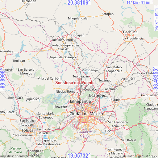
San José del Puente GPS coordinates[2]
19° 43' 14.016" North, 99° 11' 48.012" West
| Map corner | latitude | longitude |
|---|---|---|
| Upper-left | 20.38106°, | -99.8998° |
| Center: | 19.72056°, | -99.19667° |
| Lower-right: | 19.05732°, | -98.49355° |
| Map W x H: | 147.2×147.2 km | = 91.5×91.5mi |
| max Lat: | 32.7° ⇑49.1% North |
| San José del Puente: | 19.72056° |
| min Lat: | ⇓50.9% South 14.53588° |
| min Long | San José del P | max Long |
| -117.105° | -99.19667° | -86.73105° |
| W 47.3%⇐ | ⇒52.7% E |
Elevation
Elevation of San José del Puente is 2261 m = 7418 ft, and this is 1007.3 m = 3305 ft above average elevation for this country.
| Max E: |
3497 m = 11473 ft | 14.9% |
| San José del Puente | 2261 m 7418 ft | |
| Avg. | 1253.7 m = 4113 ft | |
Min E: |
-1 m = -3 ft | 85.1% |
See also: Mexico elevation on elevation.city.
Geographical zone
San José del Puente is located in North Torrid zone (between Equator and Tropic of Cancer). Distance of this Northern Tropic circle is 413.2 km =256.8 mi to North.| Distance of | km | miles | from San José del Puente |
|---|---|---|---|
| North Pole | 7814.3 | 4855.6 | to North |
| Arctic Circle | 5208.5 | 3236.4 | to North |
| Tropic Cancer | 413.2 | 256.8 | to North |
| Equator | 2192.7 | 1362.5 | to South |


Nearby cities:
15 places around San José del Puente: (largest is in red/bold)
• Ampliación los Potros (Tres Piedras)
4.6 km =2.9 mi,  289°
289°
• Axotlán
5.4 km =3.4 mi,  236°
236°
• Barrio Tlatenco
2.1 km =1.3 mi,  14°
14°
• Colonia Guadalupe
5.6 km =3.5 mi,  261°
261°
• El Ramal (Las Ladrilleras)
5.1 km =3.2 mi, 13°
• Fracción San Roque (El Prieto)
4.5 km =2.8 mi,  145°
145°
• La Trinidad
5.1 km =3.2 mi, 150°
• Lumbrera Número Diez
3.2 km =2 mi, 291°
• San Bartolo
4 km =2.5 mi,  73°
73°
• San Mateo Ixtacalco
3.5 km =2.2 mi,  132°
132°
• San Mateo Xoloc
5.6 km =3.5 mi,  253°
253°
• San Sebastián
3.9 km =2.4 mi,  331°
331°
• Santa María Huecatitla
2.9 km =1.8 mi,  80°
80°
• Teoloyucan
3.1 km =1.9 mi,  31°
31°
• Tepotzotlán
2.9 km =1.8 mi,  271°
271°
Sources, notices
• [Note1] Compared only with cities in Mexico existing in our database
• [Src1] Map data: © OpenStreetMap contributors (CC-BY-SA)
• [Src2] Other city data from geonames.org with taken over terms of usage.
• [Src3] Geographical zone / Annual Mean Temperature by Robert A. Rohde @ Wikipedia
