El Ramal (Las Ladrilleras) geodata
El Ramal (Las Ladrilleras) (State of Mexico) is a populated place; located in Mexico in America/Mexico_City (GMT-6) time zone. With population of 519 people, there are 16226 cities with bigger population in this country. Compared to other cities in Mexico, 51.8% of cities are located further ↓South; 52.5% of cities are located further →East and 84.7% of cities have lower elevation than El Ramal (Las Ladrilleras). Note1
Current local time in El Ramal (Las Ladrilleras):
09:51 PM, TuesdayDifference from your time zone: hours


El Ramal (Las Ladrilleras) GPS coordinates[2]
19° 45' 54.252" North, 99° 11' 7.08" West
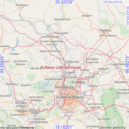
| Map corner | latitude | longitude |
|---|---|---|
| Upper-left | 20.42539°, | -99.88843° |
| Center: | 19.76507°, | -99.1853° |
| Lower-right: | 19.10201°, | -98.48218° |
| Map W x H: | 147.1×147.1 km | = 91.4×91.4mi |
| max Lat: | 32.7° ⇑48.2% North |
| El Ramal (Las Ladrilleras): | 19.76507° |
| min Lat: | ⇓51.8% South 14.53588° |
| min Long | El Ramal (Las L | max Long |
| -117.105° | -99.1853° | -86.73105° |
| W 47.5%⇐ | ⇒52.5% E |
Elevation
Elevation of El Ramal (Las Ladrilleras) is 2254 m = 7395 ft, and this is 1000.3 m = 3282 ft above average elevation for this country.
| Max E: |
3497 m = 11473 ft | 15.3% |
| El Ramal (Las Ladrilleras) | 2254 m 7395 ft | |
| Avg. | 1253.7 m = 4113 ft | |
Min E: |
-1 m = -3 ft | 84.7% |
See also: Mexico elevation on elevation.city.
Geographical zone
El Ramal (Las Ladrilleras) is located in North Torrid zone (between Equator and Tropic of Cancer). Distance of this Northern Tropic circle is 408.2 km =253.6 mi to North.| Distance of | km | miles | from El Ramal (Las Ladrilleras) |
|---|---|---|---|
| North Pole | 7809.4 | 4852.5 | to North |
| Arctic Circle | 5203.5 | 3233.3 | to North |
| Tropic Cancer | 408.2 | 253.6 | to North |
| Equator | 2197.7 | 1365.6 | to South |


Nearby cities:
15 places around El Ramal (Las Ladrilleras): (largest is in red/bold)
• Barrio Tlatenco
3 km =1.9 mi,  193°
193°
• Barrio la Tecla
4.5 km =2.8 mi,  266°
266°
• Coyotepec
3.2 km =2 mi,  295°
295°
• Ex-hacienda de Xalpa
6.3 km =3.9 mi,  2°
2°
• La Planada
1.8 km =1.1 mi,  8°
8°
• La Providencia
4.1 km =2.5 mi,  100°
100°
• Lumbrera Número Diez
5.6 km =3.5 mi,  227°
227°
• San Bartolo
4.6 km =2.9 mi,  144°
144°
• San José del Puente
5.1 km =3.2 mi, 193°
• San Sebastián
3.4 km =2.1 mi,  242°
242°
• Santa Cruz del Monte
4.5 km =2.8 mi, 272°
• Santa María Huecatitla
4.8 km =3 mi,  159°
159°
• Segunda Sección del Barrio de Santiago
4.6 km =2.9 mi,  282°
282°
• Teoloyucan
2.4 km =1.5 mi,  169°
169°
• Tepotzotlán
6.3 km =3.9 mi,  219°
219°
Sources, notices
• [Note1] Compared only with cities in Mexico existing in our database
• [Src1] Map data: © OpenStreetMap contributors (CC-BY-SA)
• [Src2] Other city data from geonames.org with taken over terms of usage.
• [Src3] Geographical zone / Annual Mean Temperature by Robert A. Rohde @ Wikipedia
