Teoloyucan geodata
Teoloyucan (State of Mexico) is a seat of a second-order administrative division; located in Mexico in America/Mexico_City (GMT-6) time zone. With population of 51,255 people, there are 221 cities with bigger population in this country. Compared to other cities in Mexico, 51.4% of cities are located further ↓South; 52.4% of cities are located further →East and 85.4% of cities have lower elevation than Teoloyucan. Note1


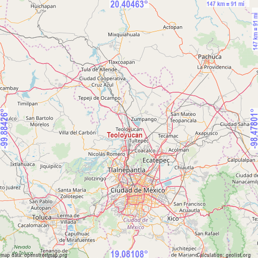
Teoloyucan GPS coordinates[2]
19° 44' 39.228" North, 99° 10' 52.068" West
| Map corner | latitude | longitude |
|---|---|---|
| Upper-left | 20.40463°, | -99.88426° |
| Center: | 19.74423°, | -99.18113° |
| Lower-right: | 19.08108°, | -98.47801° |
| Map W x H: | 147.2×147.2 km | = 91.5×91.5mi |
| max Lat: | 32.7° ⇑48.6% North |
| Teoloyucan: | 19.74423° |
| min Lat: | ⇓51.4% South 14.53588° |
| min Long | Teoloyucan | max Long |
| -117.105° | -99.18113° | -86.73105° |
| W 47.6%⇐ | ⇒52.4% E |
Elevation
Elevation of Teoloyucan is 2268 m = 7441 ft, and this is 1014.3 m = 3328 ft above average elevation for this country.
| Max E: |
3497 m = 11473 ft | 14.6% |
| Teoloyucan | 2268 m 7441 ft | |
| Avg. | 1253.7 m = 4113 ft | |
Min E: |
-1 m = -3 ft | 85.4% |
See also: Teoloyucan elevation on elevation.city.
Geographical zone
Teoloyucan is located in North Torrid zone (between Equator and Tropic of Cancer). Distance of this Northern Tropic circle is 410.6 km =255.1 mi to North.| Distance of | km | miles | from Teoloyucan |
|---|---|---|---|
| North Pole | 7811.7 | 4854 | to North |
| Arctic Circle | 5205.8 | 3234.7 | to North |
| Tropic Cancer | 410.6 | 255.1 | to North |
| Equator | 2195.4 | 1364.2 | to South |


Nearby cities:
15 places around Teoloyucan: (largest is in red/bold)
• Barrio Tlatenco
1.2 km =0.7 mi,  242°
242°
• Barrio la Tecla
5.3 km =3.3 mi,  292°
292°
• Coyotepec
5 km =3.1 mi,  317°
317°
• El Ramal (Las Ladrilleras)
2.4 km =1.5 mi,  349°
349°
• La Planada
4.1 km =2.5 mi,  357°
357°
• La Providencia
3.9 km =2.4 mi,  66°
66°
• Los Álamos II
5 km =3.1 mi,  115°
115°
• Lumbrera Número Diez
4.8 km =3 mi,  252°
252°
• San Bartolo
2.7 km =1.7 mi, 123°
• San José del Puente
3.1 km =1.9 mi,  211°
211°
• San Mateo Ixtacalco
5.1 km =3.2 mi,  168°
168°
• San Sebastián
3.6 km =2.2 mi,  282°
282°
• Santa Cruz del Monte
5.6 km =3.5 mi,  296°
296°
• Santa María Huecatitla
2.5 km =1.6 mi,  149°
149°
• Tepotzotlán
5.2 km =3.2 mi, 240°
Sources, notices
• [Note1] Compared only with cities in Mexico existing in our database
• [Src1] Map data: © OpenStreetMap contributors (CC-BY-SA)
• [Src2] Other city data from geonames.org with taken over terms of usage.
• [Src3] Geographical zone / Annual Mean Temperature by Robert A. Rohde @ Wikipedia
