El Limón geodata
El Limón (Guerrero) is a populated place; located in Mexico in America/Mexico_City (GMT-6) time zone. With population of 1,763 people, there are 4924 cities with bigger population in this country. Compared to other cities in Mexico, 89% of cities are located further ↑North; 55.3% of cities are located further →East and 66.5% of cities have higher elevation than El Limón. Note1


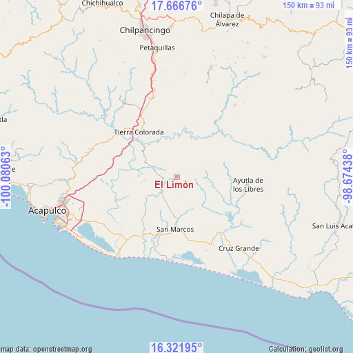
El Limón GPS coordinates[2]
16° 59' 44.016" North, 99° 22' 39" West
| Map corner | latitude | longitude |
|---|---|---|
| Upper-left | 17.66676°, | -100.08063° |
| Center: | 16.99556°, | -99.3775° |
| Lower-right: | 16.32195°, | -98.67438° |
| Map W x H: | 149.5×149.5 km | = 92.9×92.9mi |
| max Lat: | 32.7° ⇑89% North |
| El Limón: | 16.99556° |
| min Lat: | ⇓11% South 14.53588° |
| min Long | El Limón | max Long |
| -117.105° | -99.3775° | -86.73105° |
| W 44.7%⇐ | ⇒55.3% E |
Elevation
Elevation of El Limón is 611 m = 2005 ft, and this is 642.7 m = 2109 ft below average elevation for this country.
| Max E: |
3497 m = 11473 ft | 66.5% |
| Avg. | 1253.7 m = 4113 ft | |
| El Limón | 611 m = 2005 ft | |
Min E: |
-1 m = -3 ft | 33.5% |
See also: Mexico elevation on elevation.city.
Geographical zone
El Limón is located in North Torrid zone (between Equator and Tropic of Cancer). Distance of this Northern Tropic circle is 716.2 km =445 mi to North.| Distance of | km | miles | from El Limón |
|---|---|---|---|
| North Pole | 8117.3 | 5043.9 | to North |
| Arctic Circle | 5511.4 | 3424.6 | to North |
| Tropic Cancer | 716.2 | 445 | to North |
| Equator | 1889.7 | 1174.2 | to South |


Nearby cities:
15 places around El Limón: (largest is in red/bold)
• Chacalapa de Bravos
11 km =6.8 mi,  290°
290°
• Chautipa
10.8 km =6.7 mi,  352°
352°
• El Pericón
5.8 km =3.6 mi,  107°
107°
• Huamuchapa
8.5 km =5.3 mi,  132°
132°
• Las Cruces
7.6 km =4.7 mi,  250°
250°
• Las Mesas
8.7 km =5.4 mi,  279°
279°
• Las Ánimas
6.7 km =4.2 mi, 112°
• Llano Grande
8.6 km =5.3 mi,  224°
224°
• Los Saucitos
8.3 km =5.2 mi,  97°
97°
• Ocotlán
6.3 km =3.9 mi,  171°
171°
• Pochotillo
6 km =3.7 mi,  297°
297°
• Rancho Viejo
11.3 km =7 mi, 347°
• San Francisco
10.1 km =6.3 mi,  83°
83°
• Villa Hermosa
8.1 km =5 mi,  141°
141°
• Xalpatláhuac
5.9 km =3.7 mi,  58°
58°
Sources, notices
• [Note1] Compared only with cities in Mexico existing in our database
• [Src1] Map data: © OpenStreetMap contributors (CC-BY-SA)
• [Src2] Other city data from geonames.org with taken over terms of usage.
• [Src3] Geographical zone / Annual Mean Temperature by Robert A. Rohde @ Wikipedia
