Rancho Viejo geodata
Rancho Viejo (Guerrero) is a populated place; located in Mexico in America/Mexico_City (GMT-6) time zone. With population of 635 people, there are 13639 cities with bigger population in this country. Compared to other cities in Mexico, 87.7% of cities are located further ↑North; 55.6% of cities are located further →East and 70% of cities have higher elevation than Rancho Viejo. Note1


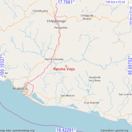
Rancho Viejo GPS coordinates[2]
17° 5' 42.972" North, 99° 24' 0.504" West
| Map corner | latitude | longitude |
|---|---|---|
| Upper-left | 17.7661°, | -100.10327° |
| Center: | 17.09527°, | -99.40014° |
| Lower-right: | 16.42201°, | -98.69702° |
| Map W x H: | 149.4×149.5 km | = 92.8×92.9mi |
| max Lat: | 32.7° ⇑87.7% North |
| Rancho Viejo: | 17.09527° |
| min Lat: | ⇓12.3% South 14.53588° |
| min Long | Rancho Viejo | max Long |
| -117.105° | -99.40014° | -86.73105° |
| W 44.4%⇐ | ⇒55.6% E |
Elevation
Elevation of Rancho Viejo is 417 m = 1368 ft, and this is 836.7 m = 2745 ft below average elevation for this country.
| Max E: |
3497 m = 11473 ft | 70% |
| Avg. | 1253.7 m = 4113 ft | |
| Rancho Viejo | 417 m = 1368 ft | |
Min E: |
-1 m = -3 ft | 30% |
See also: Mexico elevation on elevation.city.
Geographical zone
Rancho Viejo is located in North Torrid zone (between Equator and Tropic of Cancer). Distance of this Northern Tropic circle is 705.1 km =438.1 mi to North.| Distance of | km | miles | from Rancho Viejo |
|---|---|---|---|
| North Pole | 8106.2 | 5037 | to North |
| Arctic Circle | 5500.4 | 3417.8 | to North |
| Tropic Cancer | 705.1 | 438.1 | to North |
| Equator | 1900.8 | 1181.1 | to South |


Nearby cities:
15 places around Rancho Viejo: (largest is in red/bold)
• Chacalapa de Bravos
10.7 km =6.6 mi,  227°
227°
• Chautipa
1.1 km =0.7 mi,  111°
111°
• El Charco
13.7 km =8.5 mi, 106°
• El Limón
11.3 km =7 mi,  167°
167°
• El Potrero Oriental
12.7 km =7.9 mi,  305°
305°
• El Puente
6.6 km =4.1 mi,  358°
358°
• El Tabacal
6.4 km =4 mi,  71°
71°
• El Terrero
6.4 km =4 mi,  60°
60°
• La Palma
11.8 km =7.3 mi,  262°
262°
• Las Cruces
14.4 km =8.9 mi,  199°
199°
• Las Mesas
11.5 km =7.1 mi,  212°
212°
• Omitlán
11.7 km =7.3 mi,  281°
281°
• Pochotillo
8.8 km =5.5 mi, 199°
• Tlayolapa
5.2 km =3.2 mi,  31°
31°
• Xalpatláhuac
10.9 km =6.8 mi,  137°
137°
Sources, notices
• [Note1] Compared only with cities in Mexico existing in our database
• [Src1] Map data: © OpenStreetMap contributors (CC-BY-SA)
• [Src2] Other city data from geonames.org with taken over terms of usage.
• [Src3] Geographical zone / Annual Mean Temperature by Robert A. Rohde @ Wikipedia
