Huamuchapa geodata
Huamuchapa (Guerrero) is a populated place; located in Mexico in America/Mexico_City (GMT-6) time zone. With population of 2,841 people, there are 3126 cities with bigger population in this country. Compared to other cities in Mexico, 89.6% of cities are located further ↑North; 54.4% of cities are located further →East and 64.4% of cities have higher elevation than Huamuchapa. Note1


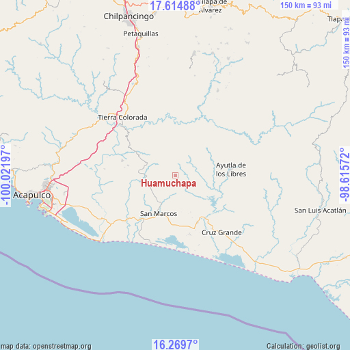
Huamuchapa GPS coordinates[2]
16° 56' 36.564" North, 99° 19' 7.824" West
| Map corner | latitude | longitude |
|---|---|---|
| Upper-left | 17.61488°, | -100.02197° |
| Center: | 16.94349°, | -99.31884° |
| Lower-right: | 16.2697°, | -98.61572° |
| Map W x H: | 149.6×149.6 km | = 93×93mi |
| max Lat: | 32.7° ⇑89.6% North |
| Huamuchapa: | 16.94349° |
| min Lat: | ⇓10.4% South 14.53588° |
| min Long | Huamuchapa | max Long |
| -117.105° | -99.31884° | -86.73105° |
| W 45.6%⇐ | ⇒54.4% E |
Elevation
Elevation of Huamuchapa is 727 m = 2385 ft, and this is 526.7 m = 1728 ft below average elevation for this country.
| Max E: |
3497 m = 11473 ft | 64.4% |
| Avg. | 1253.7 m = 4113 ft | |
| Huamuchapa | 727 m = 2385 ft | |
Min E: |
-1 m = -3 ft | 35.6% |
See also: Mexico elevation on elevation.city.
Geographical zone
Huamuchapa is located in North Torrid zone (between Equator and Tropic of Cancer). Distance of this Northern Tropic circle is 722 km =448.6 mi to North.| Distance of | km | miles | from Huamuchapa |
|---|---|---|---|
| North Pole | 8123.1 | 5047.5 | to North |
| Arctic Circle | 5517.2 | 3428.2 | to North |
| Tropic Cancer | 722 | 448.6 | to North |
| Equator | 1883.9 | 1170.6 | to South |


Nearby cities:
15 places around Huamuchapa: (largest is in red/bold)
• El Amatal
7.4 km =4.6 mi,  174°
174°
• El Limón
8.5 km =5.3 mi,  312°
312°
• El Pericón
4.1 km =2.5 mi,  349°
349°
• El Tecorral
6.8 km =4.2 mi,  131°
131°
• Las Ánimas
3.3 km =2.1 mi,  358°
358°
• Los Saucitos
5.1 km =3.2 mi,  23°
23°
• Ocotlán
5.4 km =3.4 mi,  265°
265°
• Parota Seca
6.3 km =3.9 mi,  93°
93°
• Rancho Viejo
9.3 km =5.8 mi,  160°
160°
• San Francisco
7.9 km =4.9 mi,  28°
28°
• Santa Elena Guerrero
8.6 km =5.3 mi,  191°
191°
• Santa Elena de la Villa
7.9 km =4.9 mi,  181°
181°
• Tecoanapa
8 km =5 mi,  51°
51°
• Villa Hermosa
1.3 km =0.8 mi,  245°
245°
• Xalpatláhuac
9 km =5.6 mi, 351°
Sources, notices
• [Note1] Compared only with cities in Mexico existing in our database
• [Src1] Map data: © OpenStreetMap contributors (CC-BY-SA)
• [Src2] Other city data from geonames.org with taken over terms of usage.
• [Src3] Geographical zone / Annual Mean Temperature by Robert A. Rohde @ Wikipedia
