Galaxias Toluca geodata
Galaxias Toluca (State of Mexico) is a populated place; located in Mexico in America/Mexico_City (GMT-6) time zone. With population of 1,669 people, there are 5210 cities with bigger population in this country. Compared to other cities in Mexico, 56.3% of cities are located further ↑North; 59.4% of cities are located further →East and 94.9% of cities have lower elevation than Galaxias Toluca. Note1


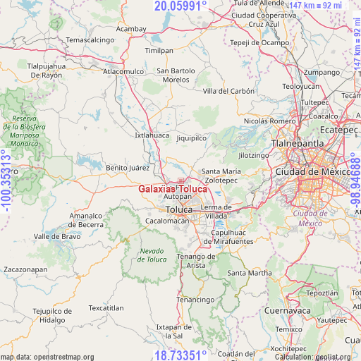
Galaxias Toluca GPS coordinates[2]
19° 23' 53.016" North, 99° 39' 0" West
| Map corner | latitude | longitude |
|---|---|---|
| Upper-left | 20.05991°, | -100.35313° |
| Center: | 19.39806°, | -99.65° |
| Lower-right: | 18.73351°, | -98.94688° |
| Map W x H: | 147.5×147.5 km | = 91.7×91.7mi |
| max Lat: | 32.7° ⇑56.3% North |
| Galaxias Toluca: | 19.39806° |
| min Lat: | ⇓43.7% South 14.53588° |
| min Long | Galaxias Toluca | max Long |
| -117.105° | -99.65° | -86.73105° |
| W 40.6%⇐ | ⇒59.4% E |
Elevation
Elevation of Galaxias Toluca is 2592 m = 8504 ft, and this is 1338.3 m = 4391 ft above average elevation for this country.
| Max E: |
3497 m = 11473 ft | 5.1% |
| Galaxias Toluca | 2592 m 8504 ft | |
| Avg. | 1253.7 m = 4113 ft | |
Min E: |
-1 m = -3 ft | 94.9% |
See also: Mexico elevation on elevation.city.
Geographical zone
Galaxias Toluca is located in North Torrid zone (between Equator and Tropic of Cancer). Distance of this Northern Tropic circle is 449.1 km =279.1 mi to North.| Distance of | km | miles | from Galaxias Toluca |
|---|---|---|---|
| North Pole | 7850.2 | 4877.9 | to North |
| Arctic Circle | 5244.3 | 3258.7 | to North |
| Tropic Cancer | 449.1 | 279.1 | to North |
| Equator | 2156.9 | 1340.2 | to South |


Nearby cities:
15 places around Galaxias Toluca: (largest is in red/bold)
• Barrio Bordo Nuevo
3.2 km =2 mi,  229°
229°
• Barrio del Cajón
1.1 km =0.7 mi, 228°
• Fraccionamiento Real de San Pablo
1 km =0.6 mi,  171°
171°
• Jicaltepec Autopan
3.1 km =1.9 mi,  161°
161°
• Jicaltepec Cuexcontitlán
3.6 km =2.2 mi,  139°
139°
• La Loma Cuexcontitlán
2 km =1.2 mi,  176°
176°
• Llano de la Y
3.6 km =2.2 mi,  81°
81°
• Loma de Progreso
4.1 km =2.5 mi,  38°
38°
• San Antonio del Puente
4.1 km =2.5 mi,  56°
56°
• San Carlos Autopan
4.1 km =2.5 mi,  250°
250°
• San Diego Linares
1.9 km =1.2 mi,  134°
134°
• San Diego los Padres Cuexcontitlán Sección 5 B
4.7 km =2.9 mi,  121°
121°
• San José Pathé
4.6 km =2.9 mi,  25°
25°
• San José la Costa
3.8 km =2.4 mi,  10°
10°
• San Pablo Autopan
4.7 km =2.9 mi,  189°
189°
Sources, notices
• [Note1] Compared only with cities in Mexico existing in our database
• [Src1] Map data: © OpenStreetMap contributors (CC-BY-SA)
• [Src2] Other city data from geonames.org with taken over terms of usage.
• [Src3] Geographical zone / Annual Mean Temperature by Robert A. Rohde @ Wikipedia
