Santa Clara del Tule geodata
Santa Clara del Tule (Michoacán) is a populated place; located in Mexico in America/Mexico_City (GMT-6) time zone. With population of 1,326 people, there are 6543 cities with bigger population in this country. Compared to other cities in Mexico, 53.4% of cities are located further ↓South; 72.1% of cities are located further →East and 69.2% of cities have lower elevation than Santa Clara del Tule. Note1


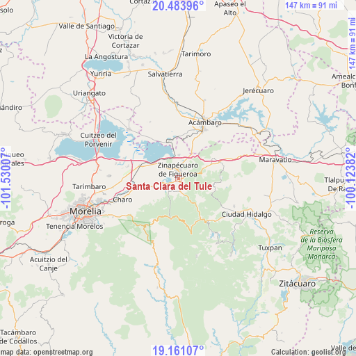
Santa Clara del Tule GPS coordinates[2]
19° 49' 26.004" North, 100° 49' 36.984" West
| Map corner | latitude | longitude |
|---|---|---|
| Upper-left | 20.48396°, | -101.53007° |
| Center: | 19.82389°, | -100.82694° |
| Lower-right: | 19.16107°, | -100.12382° |
| Map W x H: | 147.1×147.1 km | = 91.4×91.4mi |
| max Lat: | 32.7° ⇑46.6% North |
| Santa Clara del Tule: | 19.82389° |
| min Lat: | ⇓53.4% South 14.53588° |
| min Long | Santa Clara del | max Long |
| -117.105° | -100.82694° | -86.73105° |
| W 27.9%⇐ | ⇒72.1% E |
Elevation
Elevation of Santa Clara del Tule is 1911 m = 6270 ft, and this is 657.3 m = 2156 ft above average elevation for this country.
| Max E: |
3497 m = 11473 ft | 30.8% |
| Santa Clara del Tule | 1911 m 6270 ft | |
| Avg. | 1253.7 m = 4113 ft | |
Min E: |
-1 m = -3 ft | 69.2% |
See also: Mexico elevation on elevation.city.
Geographical zone
Santa Clara del Tule is located in North Torrid zone (between Equator and Tropic of Cancer). Distance of this Northern Tropic circle is 401.7 km =249.6 mi to North.| Distance of | km | miles | from Santa Clara del Tule |
|---|---|---|---|
| North Pole | 7802.9 | 4848.5 | to North |
| Arctic Circle | 5197 | 3229.3 | to North |
| Tropic Cancer | 401.7 | 249.6 | to North |
| Equator | 2204.2 | 1369.6 | to South |


Nearby cities:
15 places around Santa Clara del Tule: (largest is in red/bold)
• Araró
9.7 km =6 mi,  1°
1°
• Bocaneo (San Pedro)
1.9 km =1.2 mi,  31°
31°
• Colonia de Guadalupe
9.6 km =6 mi,  254°
254°
• El Castillo
6 km =3.7 mi,  226°
226°
• Estación Queréndaro
14.3 km =8.9 mi,  297°
297°
• Francisco Villa
12.7 km =7.9 mi, 296°
• José María Morelos (La Yegüería)
7 km =4.3 mi,  309°
309°
• Ojo de Agua de Bucio
11.4 km =7.1 mi,  115°
115°
• Pueblo Viejo
5.4 km =3.4 mi,  166°
166°
• Queréndaro
6.8 km =4.2 mi,  256°
256°
• Río de Parras (Otzumatlán)
6.9 km =4.3 mi,  216°
216°
• San Bartolomé Coro
9.3 km =5.8 mi,  327°
327°
• San Lucas Pío
10.8 km =6.7 mi, 251°
• San Miguel Taimeo
3.7 km =2.3 mi,  55°
55°
• Zinapécuaro
4 km =2.5 mi,  357°
357°
Sources, notices
• [Note1] Compared only with cities in Mexico existing in our database
• [Src1] Map data: © OpenStreetMap contributors (CC-BY-SA)
• [Src2] Other city data from geonames.org with taken over terms of usage.
• [Src3] Geographical zone / Annual Mean Temperature by Robert A. Rohde @ Wikipedia
