Plaza Nueva geodata
Plaza Nueva (State of Mexico) is a populated place; located in Mexico in America/Mexico_City (GMT-6) time zone. With population of 1,292 people, there are 6710 cities with bigger population in this country. Compared to other cities in Mexico, 66.3% of cities are located further ↑North; 56% of cities are located further →East and 58.3% of cities have lower elevation than Plaza Nueva. Note1


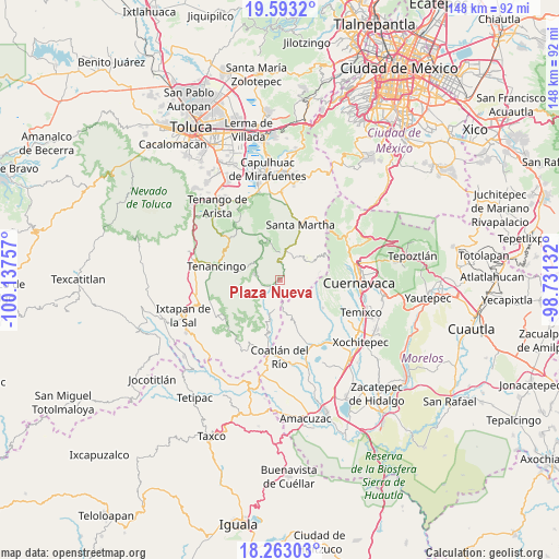
Plaza Nueva GPS coordinates[2]
18° 55' 45.984" North, 99° 26' 3.984" West
| Map corner | latitude | longitude |
|---|---|---|
| Upper-left | 19.5932°, | -100.13757° |
| Center: | 18.92944°, | -99.43444° |
| Lower-right: | 18.26303°, | -98.73132° |
| Map W x H: | 147.9×147.9 km | = 91.9×91.9mi |
| max Lat: | 32.7° ⇑66.3% North |
| Plaza Nueva: | 18.92944° |
| min Lat: | ⇓33.7% South 14.53588° |
| min Long | Plaza Nueva | max Long |
| -117.105° | -99.43444° | -86.73105° |
| W 44%⇐ | ⇒56% E |
Elevation
Elevation of Plaza Nueva is 1695 m = 5561 ft, and this is 441.3 m = 1448 ft above average elevation for this country.
| Max E: |
3497 m = 11473 ft | 41.7% |
| Plaza Nueva | 1695 m 5561 ft | |
| Avg. | 1253.7 m = 4113 ft | |
Min E: |
-1 m = -3 ft | 58.3% |
See also: Mexico elevation on elevation.city.
Geographical zone
Plaza Nueva is located in North Torrid zone (between Equator and Tropic of Cancer). Distance of this Northern Tropic circle is 501.2 km =311.4 mi to North.| Distance of | km | miles | from Plaza Nueva |
|---|---|---|---|
| North Pole | 7902.3 | 4910.3 | to North |
| Arctic Circle | 5296.4 | 3291 | to North |
| Tropic Cancer | 501.2 | 311.4 | to North |
| Equator | 2104.8 | 1307.9 | to South |


Nearby cities:
15 places around Plaza Nueva: (largest is in red/bold)
• Chalma
0.1 km =0.1 mi,  330°
330°
• Chalmita
1.3 km =0.8 mi,  65°
65°
• El Puentecito
4.3 km =2.7 mi,  249°
249°
• Jalmolonga (La Hacienda)
6.4 km =4 mi,  258°
258°
• La Cañada
1.8 km =1.1 mi,  29°
29°
• La Ciénega
7.1 km =4.4 mi,  353°
353°
• La Ladrillera
5.1 km =3.2 mi,  267°
267°
• Los Manantiales (El Río Chiquito)
0.5 km =0.3 mi,  239°
239°
• Malinalco
6.8 km =4.2 mi,  288°
288°
• Ocuilan de Arteaga
5.6 km =3.5 mi,  15°
15°
• Palpan de Baranda
6.7 km =4.2 mi,  175°
175°
• Puente Caporal (La Guancha)
3.8 km =2.4 mi,  214°
214°
• Reforma Agraria (El Pedregal)
7.3 km =4.5 mi,  357°
357°
• Santa Ana
6.8 km =4.2 mi, 18°
• Santa Mónica
7.2 km =4.5 mi,  9°
9°
Sources, notices
• [Note1] Compared only with cities in Mexico existing in our database
• [Src1] Map data: © OpenStreetMap contributors (CC-BY-SA)
• [Src2] Other city data from geonames.org with taken over terms of usage.
• [Src3] Geographical zone / Annual Mean Temperature by Robert A. Rohde @ Wikipedia
