Palpan de Baranda geodata
Palpan de Baranda (Morelos) is a populated place; located in Mexico in America/Mexico_City (GMT-6) time zone. With population of 791 people, there are 11037 cities with bigger population in this country. Compared to other cities in Mexico, 67.7% of cities are located further ↑North; 56% of cities are located further →East and 56% of cities have lower elevation than Palpan de Baranda. Note1


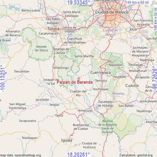
Palpan de Baranda GPS coordinates[2]
18° 52' 10.02" North, 99° 25' 45.768" West
| Map corner | latitude | longitude |
|---|---|---|
| Upper-left | 19.53345°, | -100.13251° |
| Center: | 18.86945°, | -99.42938° |
| Lower-right: | 18.20281°, | -98.72626° |
| Map W x H: | 148×148 km | = 92×92mi |
| max Lat: | 32.7° ⇑67.7% North |
| Palpan de Baranda: | 18.86945° |
| min Lat: | ⇓32.3% South 14.53588° |
| min Long | Palpan de Baran | max Long |
| -117.105° | -99.42938° | -86.73105° |
| W 44%⇐ | ⇒56% E |
Elevation
Elevation of Palpan de Baranda is 1620 m = 5315 ft, and this is 366.3 m = 1202 ft above average elevation for this country.
| Max E: |
3497 m = 11473 ft | 44% |
| Palpan de Baranda | 1620 m 5315 ft | |
| Avg. | 1253.7 m = 4113 ft | |
Min E: |
-1 m = -3 ft | 56% |
See also: Mexico elevation on elevation.city.
Geographical zone
Palpan de Baranda is located in North Torrid zone (between Equator and Tropic of Cancer). Distance of this Northern Tropic circle is 507.8 km =315.5 mi to North.| Distance of | km | miles | from Palpan de Baranda |
|---|---|---|---|
| North Pole | 7909 | 4914.4 | to North |
| Arctic Circle | 5303.1 | 3295.2 | to North |
| Tropic Cancer | 507.8 | 315.5 | to North |
| Equator | 2098.1 | 1303.7 | to South |


Nearby cities:
15 places around Palpan de Baranda: (largest is in red/bold)
• Chalma
6.8 km =4.2 mi,  354°
354°
• Chalmita
7.2 km =4.5 mi,  5°
5°
• Colonia Juárez
8 km =5 mi,  201°
201°
• Cuentepec
10.9 km =6.8 mi,  94°
94°
• El Platanar
5.2 km =3.2 mi,  213°
213°
• El Puentecito
6.9 km =4.3 mi,  318°
318°
• Jalmolonga (La Hacienda)
8.7 km =5.4 mi,  308°
308°
• La Cañada
8.3 km =5.2 mi,  2°
2°
• La Ladrillera
8.6 km =5.3 mi, 318°
• Los Manantiales (El Río Chiquito)
6.5 km =4 mi, 351°
• Malinalco
11.3 km =7 mi, 321°
• Noxtepec de Zaragoza (El Aguacate)
8.2 km =5.1 mi,  218°
218°
• Palmar de Guadalupe
11.8 km =7.3 mi,  289°
289°
• Plaza Nueva
6.7 km =4.2 mi,  355°
355°
• Puente Caporal (La Guancha)
4.5 km =2.8 mi, 323°
Sources, notices
• [Note1] Compared only with cities in Mexico existing in our database
• [Src1] Map data: © OpenStreetMap contributors (CC-BY-SA)
• [Src2] Other city data from geonames.org with taken over terms of usage.
• [Src3] Geographical zone / Annual Mean Temperature by Robert A. Rohde @ Wikipedia
