Doxteje Centro geodata
Doxteje Centro (State of Mexico) is a populated place; located in Mexico in America/Mexico_City (GMT-6) time zone. With population of 1,121 people, there are 7740 cities with bigger population in this country. Compared to other cities in Mexico, 56.5% of cities are located further ↓South; 63.4% of cities are located further →East and 96.5% of cities have lower elevation than Doxteje Centro. Note1


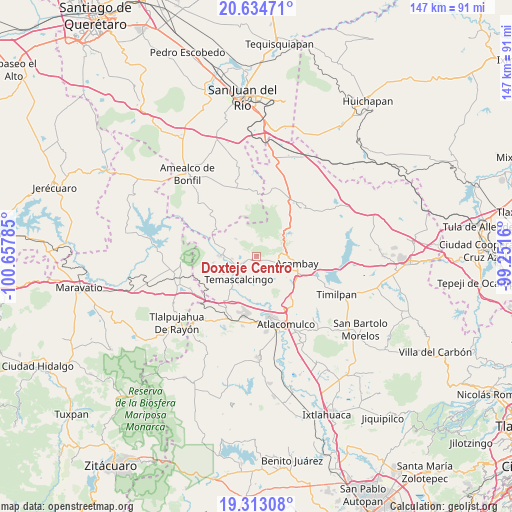
Doxteje Centro GPS coordinates[2]
19° 58' 31.008" North, 99° 57' 16.992" West
| Map corner | latitude | longitude |
|---|---|---|
| Upper-left | 20.63471°, | -100.65785° |
| Center: | 19.97528°, | -99.95472° |
| Lower-right: | 19.31308°, | -99.2516° |
| Map W x H: | 147×147 km | = 91.3×91.3mi |
| max Lat: | 32.7° ⇑43.5% North |
| Doxteje Centro: | 19.97528° |
| min Lat: | ⇓56.5% South 14.53588° |
| min Long | Doxteje Centro | max Long |
| -117.105° | -99.95472° | -86.73105° |
| W 36.6%⇐ | ⇒63.4% E |
Elevation
Elevation of Doxteje Centro is 2650 m = 8694 ft, and this is 1396.3 m = 4581 ft above average elevation for this country.
| Max E: |
3497 m = 11473 ft | 3.5% |
| Doxteje Centro | 2650 m 8694 ft | |
| Avg. | 1253.7 m = 4113 ft | |
Min E: |
-1 m = -3 ft | 96.5% |
See also: Mexico elevation on elevation.city.
Geographical zone
Doxteje Centro is located in North Torrid zone (between Equator and Tropic of Cancer). Distance of this Northern Tropic circle is 384.9 km =239.2 mi to North.| Distance of | km | miles | from Doxteje Centro |
|---|---|---|---|
| North Pole | 7786 | 4838 | to North |
| Arctic Circle | 5180.1 | 3218.8 | to North |
| Tropic Cancer | 384.9 | 239.2 | to North |
| Equator | 2221 | 1380.1 | to South |


Nearby cities:
15 places around Doxteje Centro: (largest is in red/bold)
• Ahuacatitlan Centro
4.4 km =2.7 mi,  237°
237°
• Ahuacatitlán Cuarto y Quinto Cuartel
3.7 km =2.3 mi,  246°
246°
• Calderas
6.4 km =4 mi,  282°
282°
• Cerritos de Cárdenas
7.1 km =4.4 mi,  264°
264°
• Conejeras
4.2 km =2.6 mi,  349°
349°
• Detiña (San Antonio Detiña)
7.4 km =4.6 mi,  94°
94°
• Doxteje Barrio Primero
1.8 km =1.1 mi,  193°
193°
• Doxtejé Centro
0.6 km =0.4 mi,  164°
164°
• La Loma
7.6 km =4.7 mi,  310°
310°
• La Magdalena
5.6 km =3.5 mi, 236°
• La Palma
6.1 km =3.8 mi,  48°
48°
• Pueblo Nuevo
5.9 km =3.7 mi,  135°
135°
• Puentecillas
6.1 km =3.8 mi,  336°
336°
• San Pedro el Alto
7.3 km =4.5 mi, 187°
• Tixmadeje Chiquito
4.3 km =2.7 mi,  104°
104°
Sources, notices
• [Note1] Compared only with cities in Mexico existing in our database
• [Src1] Map data: © OpenStreetMap contributors (CC-BY-SA)
• [Src2] Other city data from geonames.org with taken over terms of usage.
• [Src3] Geographical zone / Annual Mean Temperature by Robert A. Rohde @ Wikipedia
