La Loma geodata
La Loma (State of Mexico) is a populated place; located in Mexico in America/Mexico_City (GMT-6) time zone. With population of 1,274 people, there are 6799 cities with bigger population in this country. Compared to other cities in Mexico, 57.4% of cities are located further ↓South; 64.1% of cities are located further →East and 97.3% of cities have lower elevation than La Loma. Note1


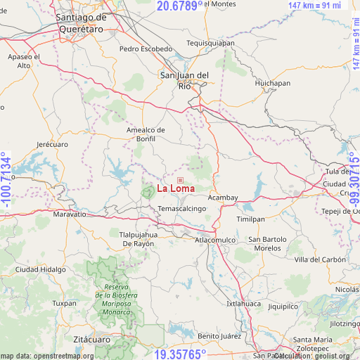
La Loma GPS coordinates[2]
20° 1' 10.776" North, 100° 0' 36.972" West
| Map corner | latitude | longitude |
|---|---|---|
| Upper-left | 20.6789°, | -100.7134° |
| Center: | 20.01966°, | -100.01027° |
| Lower-right: | 19.35765°, | -99.30715° |
| Map W x H: | 146.9×146.9 km | = 91.3×91.3mi |
| max Lat: | 32.7° ⇑42.6% North |
| La Loma: | 20.01966° |
| min Lat: | ⇓57.4% South 14.53588° |
| min Long | La Loma | max Long |
| -117.105° | -100.01027° | -86.73105° |
| W 35.9%⇐ | ⇒64.1% E |
Elevation
Elevation of La Loma is 2703 m = 8868 ft, and this is 1449.3 m = 4755 ft above average elevation for this country.
| Max E: |
3497 m = 11473 ft | 2.7% |
| La Loma | 2703 m 8868 ft | |
| Avg. | 1253.7 m = 4113 ft | |
Min E: |
-1 m = -3 ft | 97.3% |
See also: Mexico elevation on elevation.city.
Geographical zone
La Loma is located in North Torrid zone (between Equator and Tropic of Cancer). Distance of this Northern Tropic circle is 379.9 km =236.1 mi to North.| Distance of | km | miles | from La Loma |
|---|---|---|---|
| North Pole | 7781.1 | 4834.9 | to North |
| Arctic Circle | 5175.2 | 3215.7 | to North |
| Tropic Cancer | 379.9 | 236.1 | to North |
| Equator | 2226 | 1383.2 | to South |


Nearby cities:
15 places around La Loma: (largest is in red/bold)
• Agostadero (San José Agostadero)
2.5 km =1.6 mi,  20°
20°
• Ahuacatitlan Centro
7.6 km =4.7 mi,  163°
163°
• Ahuacatitlán Cuarto y Quinto Cuartel
6.8 km =4.2 mi, 159°
• Calderas
3.6 km =2.2 mi,  186°
186°
• Cerritos de Cárdenas
5.7 km =3.5 mi, 192°
• Conejeras
5.1 km =3.2 mi,  98°
98°
• Donicá
6.8 km =4.2 mi,  289°
289°
• Doxteje Centro
7.6 km =4.7 mi,  130°
130°
• Doxtejé Centro
8.1 km =5 mi, 132°
• Juando
1.6 km =1 mi,  42°
42°
• Puentecillas
3.4 km =2.1 mi,  78°
78°
• San Francisco Shaxni Ejido
6 km =3.7 mi,  14°
14°
• San Jose Solís
4.7 km =2.9 mi,  240°
240°
• San Nicolás Solís
3.6 km =2.2 mi,  207°
207°
• Santiago Mexquititlán Barrio 4to.
7.8 km =4.8 mi,  308°
308°
Sources, notices
• [Note1] Compared only with cities in Mexico existing in our database
• [Src1] Map data: © OpenStreetMap contributors (CC-BY-SA)
• [Src2] Other city data from geonames.org with taken over terms of usage.
• [Src3] Geographical zone / Annual Mean Temperature by Robert A. Rohde @ Wikipedia
