Puentecillas geodata
Puentecillas (State of Mexico) is a populated place; located in Mexico in America/Mexico_City (GMT-6) time zone. With population of 1,851 people, there are 4691 cities with bigger population in this country. Compared to other cities in Mexico, 57.5% of cities are located further ↓South; 63.7% of cities are located further →East and 99.4% of cities have lower elevation than Puentecillas. Note1


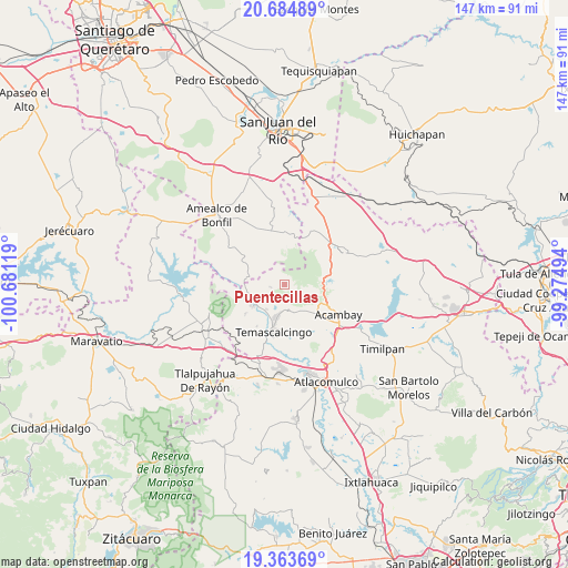
Puentecillas GPS coordinates[2]
20° 1' 32.448" North, 99° 58' 41.016" West
| Map corner | latitude | longitude |
|---|---|---|
| Upper-left | 20.68489°, | -100.68119° |
| Center: | 20.02568°, | -99.97806° |
| Lower-right: | 19.36369°, | -99.27494° |
| Map W x H: | 146.9×146.9 km | = 91.3×91.3mi |
| max Lat: | 32.7° ⇑42.5% North |
| Puentecillas: | 20.02568° |
| min Lat: | ⇓57.5% South 14.53588° |
| min Long | Puentecillas | max Long |
| -117.105° | -99.97806° | -86.73105° |
| W 36.3%⇐ | ⇒63.7% E |
Elevation
Elevation of Puentecillas is 2889 m = 9478 ft, and this is 1635.3 m = 5365 ft above average elevation for this country.
| Max E: |
3497 m = 11473 ft | 0.59999999999999% |
| Puentecillas | 2889 m 9478 ft | |
| Avg. | 1253.7 m = 4113 ft | |
Min E: |
-1 m = -3 ft | 99.4% |
See also: Mexico elevation on elevation.city.
Geographical zone
Puentecillas is located in North Torrid zone (between Equator and Tropic of Cancer). Distance of this Northern Tropic circle is 379.3 km =235.7 mi to North.| Distance of | km | miles | from Puentecillas |
|---|---|---|---|
| North Pole | 7780.4 | 4834.5 | to North |
| Arctic Circle | 5174.5 | 3215.3 | to North |
| Tropic Cancer | 379.3 | 235.7 | to North |
| Equator | 2226.6 | 1383.5 | to South |


Nearby cities:
15 places around Puentecillas: (largest is in red/bold)
• Agostadero (San José Agostadero)
3 km =1.9 mi,  303°
303°
• Ahuacatitlán Cuarto y Quinto Cuartel
7.1 km =4.4 mi,  187°
187°
• Calderas
5.7 km =3.5 mi,  221°
221°
• Cerritos de Cárdenas
7.8 km =4.8 mi, 216°
• Conejeras
2.2 km =1.4 mi,  130°
130°
• Doxteje Barrio Primero
7.6 km =4.7 mi,  164°
164°
• Doxteje Centro
6.1 km =3.8 mi, 156°
• Doxtejé Centro
6.7 km =4.2 mi, 157°
• Juando
2.3 km =1.4 mi,  283°
283°
• La Loma
3.4 km =2.1 mi,  258°
258°
• La Palma
7.2 km =4.5 mi,  102°
102°
• San Francisco Shaxni Ejido
5.4 km =3.4 mi,  340°
340°
• San Jose Solís
8 km =5 mi,  248°
248°
• San Nicolás Solís
6.3 km =3.9 mi,  232°
232°
• San Pablo
7 km =4.3 mi,  0°
0°
Sources, notices
• [Note1] Compared only with cities in Mexico existing in our database
• [Src1] Map data: © OpenStreetMap contributors (CC-BY-SA)
• [Src2] Other city data from geonames.org with taken over terms of usage.
• [Src3] Geographical zone / Annual Mean Temperature by Robert A. Rohde @ Wikipedia
