Luis Espinoza geodata
Luis Espinoza (Chiapas) is a populated place; located in Mexico in America/Mexico_City (GMT-6) time zone. With population of 1,107 people, there are 7851 cities with bigger population in this country. Compared to other cities in Mexico, 88.5% of cities are located further ↑North; 88.4% of cities are located further ←West and 50.2% of cities have lower elevation than Luis Espinoza. Note1


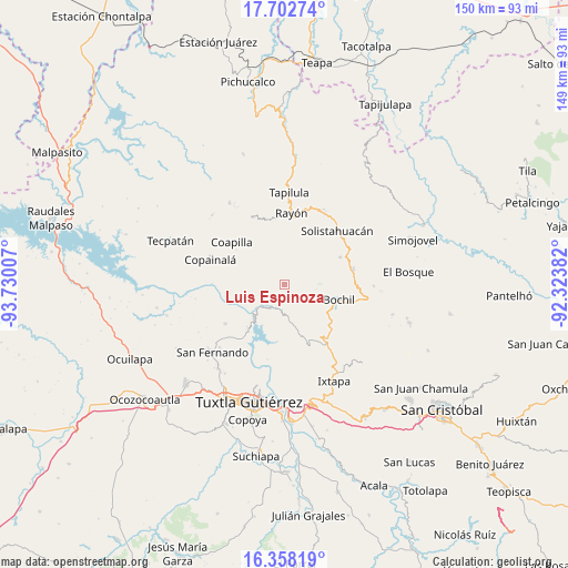
Luis Espinoza GPS coordinates[2]
17° 1' 54.012" North, 93° 1' 36.984" West
| Map corner | latitude | longitude |
|---|---|---|
| Upper-left | 17.70274°, | -93.73007° |
| Center: | 17.03167°, | -93.02694° |
| Lower-right: | 16.35819°, | -92.32382° |
| Map W x H: | 149.5×149.5 km | = 92.9×92.9mi |
| max Lat: | 32.7° ⇑88.5% North |
| Luis Espinoza: | 17.03167° |
| min Lat: | ⇓11.5% South 14.53588° |
| min Long | Luis Espinoza | max Long |
| -117.105° | -93.02694° | -86.73105° |
| W 88.4%⇐ | ⇒11.6% E |
Elevation
Elevation of Luis Espinoza is 1442 m = 4731 ft, and this is 188.3 m = 618 ft above average elevation for this country.
| Max E: |
3497 m = 11473 ft | 49.8% |
| Luis Espinoza | 1442 m 4731 ft | |
| Avg. | 1253.7 m = 4113 ft | |
Min E: |
-1 m = -3 ft | 50.2% |
See also: Mexico elevation on elevation.city.
Geographical zone
Luis Espinoza is located in North Torrid zone (between Equator and Tropic of Cancer). Distance of this Northern Tropic circle is 712.2 km =442.5 mi to North.| Distance of | km | miles | from Luis Espinoza |
|---|---|---|---|
| North Pole | 8113.3 | 5041.4 | to North |
| Arctic Circle | 5507.4 | 3422.1 | to North |
| Tropic Cancer | 712.2 | 442.5 | to North |
| Equator | 1893.7 | 1176.7 | to South |


Nearby cities:
15 places around Luis Espinoza: (largest is in red/bold)
• Ajilhó
10.9 km =6.8 mi,  119°
119°
• Allende Esquipulas
8.7 km =5.4 mi,  62°
62°
• Buenavista (Matasanos)
9.5 km =5.9 mi,  333°
333°
• Chicoasén
11 km =6.8 mi,  228°
228°
• El Amate
10.5 km =6.5 mi,  12°
12°
• Francisco Sarabia
9.7 km =6 mi,  171°
171°
• Garrido Canaval
4.7 km =2.9 mi,  359°
359°
• José María Morelos y Pavón
12.2 km =7.6 mi,  292°
292°
• Julián Grajales
12.1 km =7.5 mi,  25°
25°
• Llano Grande
4.9 km =3 mi,  88°
88°
• Osumacinta
12.6 km =7.8 mi,  212°
212°
• San Antonio Zaragoza
12.5 km =7.8 mi,  183°
183°
• San Pedro el Achiote (San Pedro Mártir)
10.7 km =6.6 mi,  108°
108°
• Tierra Colorada
12.1 km =7.5 mi,  98°
98°
• Vicente Guerrero
11.7 km =7.3 mi,  342°
342°
Sources, notices
• [Note1] Compared only with cities in Mexico existing in our database
• [Src1] Map data: © OpenStreetMap contributors (CC-BY-SA)
• [Src2] Other city data from geonames.org with taken over terms of usage.
• [Src3] Geographical zone / Annual Mean Temperature by Robert A. Rohde @ Wikipedia
