Allende Esquipulas geodata
Allende Esquipulas (Chiapas) is a populated place; located in Mexico in America/Mexico_City (GMT-6) time zone. With population of 657 people, there are 13209 cities with bigger population in this country. Compared to other cities in Mexico, 88% of cities are located further ↑North; 88.9% of cities are located further ←West and 53.7% of cities have higher elevation than Allende Esquipulas. Note1


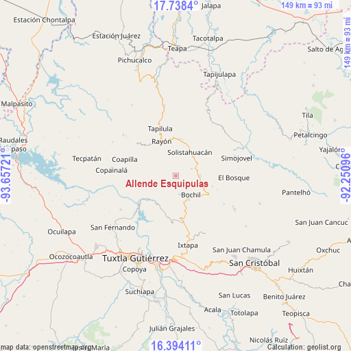
Allende Esquipulas GPS coordinates[2]
17° 4' 2.892" North, 92° 57' 14.688" West
| Map corner | latitude | longitude |
|---|---|---|
| Upper-left | 17.7384°, | -93.65721° |
| Center: | 17.06747°, | -92.95408° |
| Lower-right: | 16.39411°, | -92.25096° |
| Map W x H: | 149.5×149.5 km | = 92.9×92.9mi |
| max Lat: | 32.7° ⇑88% North |
| Allende Esquipulas: | 17.06747° |
| min Lat: | ⇓12% South 14.53588° |
| min Long | Allende Esquipu | max Long |
| -117.105° | -92.95408° | -86.73105° |
| W 88.9%⇐ | ⇒11.1% E |
Elevation
Elevation of Allende Esquipulas is 1261 m = 4137 ft, and this is 7.3 m = 24 ft above average elevation for this country.
| Max E: |
3497 m = 11473 ft | 53.7% |
| Allende Esquipulas | 1261 m 4137 ft | |
| Avg. | 1253.7 m = 4113 ft | |
Min E: |
-1 m = -3 ft | 46.3% |
See also: Mexico elevation on elevation.city.
Geographical zone
Allende Esquipulas is located in North Torrid zone (between Equator and Tropic of Cancer). Distance of this Northern Tropic circle is 708.2 km =440.1 mi to North.| Distance of | km | miles | from Allende Esquipulas |
|---|---|---|---|
| North Pole | 8109.3 | 5038.9 | to North |
| Arctic Circle | 5503.4 | 3419.7 | to North |
| Tropic Cancer | 708.2 | 440.1 | to North |
| Equator | 1897.7 | 1179.2 | to South |


Nearby cities:
15 places around Allende Esquipulas: (largest is in red/bold)
• Ajilhó
9.5 km =5.9 mi,  169°
169°
• Bochil
10.3 km =6.4 mi,  140°
140°
• El Amate
8.3 km =5.2 mi,  318°
318°
• El Copal
11.5 km =7.1 mi, 165°
• Garrido Canaval
7.8 km =4.8 mi,  275°
275°
• Jitotol
9.9 km =6.2 mi,  90°
90°
• Julián Grajales
7.4 km =4.6 mi,  339°
339°
• Llano Grande
4.8 km =3 mi,  216°
216°
• Luis Espinoza
8.7 km =5.4 mi,  242°
242°
• Maravillas
7.5 km =4.7 mi,  63°
63°
• Pueblo Nuevo
11.8 km =7.3 mi,  29°
29°
• San Pedro el Achiote (San Pedro Mártir)
7.9 km =4.9 mi,  162°
162°
• Tierra Colorada
7.2 km =4.5 mi, 144°
• Unión Zaragoza
11.5 km =7.1 mi,  82°
82°
• Venustiano Carranza
12.1 km =7.5 mi, 167°
Sources, notices
• [Note1] Compared only with cities in Mexico existing in our database
• [Src1] Map data: © OpenStreetMap contributors (CC-BY-SA)
• [Src2] Other city data from geonames.org with taken over terms of usage.
• [Src3] Geographical zone / Annual Mean Temperature by Robert A. Rohde @ Wikipedia
