J. Jesús González Ortega (San Mateo) geodata
J. Jesús González Ortega (San Mateo) (Zacatecas) is a populated place; located in Mexico in America/Mexico_City (GMT-6) time zone. With population of 1,100 people, there are 7910 cities with bigger population in this country. Compared to other cities in Mexico, 87.8% of cities are located further ↓South; 88.3% of cities are located further →East and 73.3% of cities have lower elevation than J. Jesús González Ortega (San Mateo). Note1
Current local time in J. Jesús González Ortega (San Mateo):
08:34 AM, WednesdayDifference from your time zone: hours


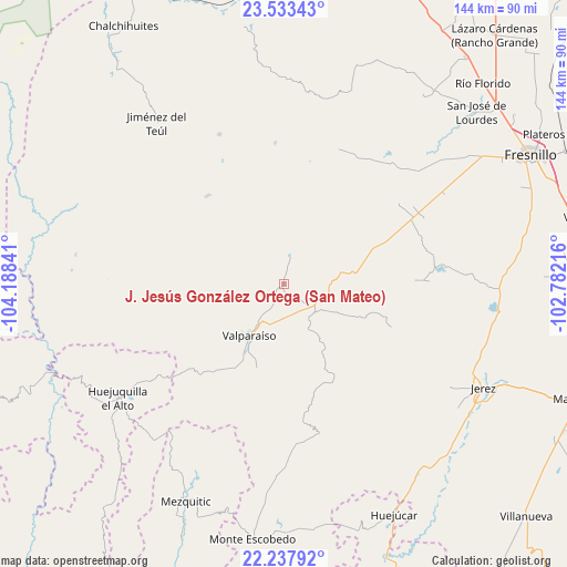
J. Jesús González Ortega (San Mateo) GPS coordinates[2]
22° 53' 13.992" North, 103° 29' 7.008" West
| Map corner | latitude | longitude |
|---|---|---|
| Upper-left | 23.53343°, | -104.18841° |
| Center: | 22.88722°, | -103.48528° |
| Lower-right: | 22.23792°, | -102.78216° |
| Map W x H: | 144×144 km | = 89.5×89.5mi |
| max Lat: | 32.7° ⇑12.2% North |
| J. Jesús González Ortega (San Mateo): | 22.88722° |
| min Lat: | ⇓87.8% South 14.53588° |
| min Long | J. Jesús Gonz� | max Long |
| -117.105° | -103.48528° | -86.73105° |
| W 11.7%⇐ | ⇒88.3% E |
Elevation
Elevation of J. Jesús González Ortega (San Mateo) is 1998 m = 6555 ft, and this is 744.3 m = 2442 ft above average elevation for this country.
| Max E: |
3497 m = 11473 ft | 26.7% |
| J. Jesús González Ortega (San Mateo) | 1998 m 6555 ft | |
| Avg. | 1253.7 m = 4113 ft | |
Min E: |
-1 m = -3 ft | 73.3% |
See also: Mexico elevation on elevation.city.
Geographical zone
J. Jesús González Ortega (San Mateo) is located in North Torrid zone (between Equator and Tropic of Cancer). Distance of this Northern Tropic circle is 61.1 km =38 mi to North.| Distance of | km | miles | from J. Jesús González Ortega (San Mateo) |
|---|---|---|---|
| North Pole | 7462.2 | 4636.8 | to North |
| Arctic Circle | 4856.4 | 3017.6 | to North |
| Tropic Cancer | 61.1 | 38 | to North |
| Equator | 2544.8 | 1581.3 | to South |


Nearby cities:
15 places around J. Jesús González Ortega (San Mateo): (largest is in red/bold)
• Buenavista de Trujillo
42.4 km =26.3 mi,  45°
45°
• Ermita de los Correas
48.2 km =30 mi,  87°
87°
• Guadalupe Trujillo
35.7 km =22.2 mi,  55°
55°
• Labor de Santa Barbara
32.1 km =19.9 mi, 63°
• Laguna Grande
49.6 km =30.8 mi,  182°
182°
• Lobatos
10.8 km =6.7 mi,  131°
131°
• Matías Ramos
38.3 km =23.8 mi, 53°
• Melchor Ocampo (San Jerónimo)
44.2 km =27.5 mi, 49°
• Milpillas de la Sierra
29.7 km =18.5 mi,  318°
318°
• San José del Río
41.3 km =25.7 mi,  32°
32°
• Santa Rosa
38.5 km =23.9 mi,  83°
83°
• Tapias de Santa Cruz (Pedro Ruiz González)
49.4 km =30.7 mi, 47°
• Trojes
8.8 km =5.5 mi,  216°
216°
• Trujillo
43.6 km =27.1 mi, 45°
• Valparaíso
15.6 km =9.7 mi,  213°
213°
Sources, notices
• [Note1] Compared only with cities in Mexico existing in our database
• [Src1] Map data: © OpenStreetMap contributors (CC-BY-SA)
• [Src2] Other city data from geonames.org with taken over terms of usage.
• [Src3] Geographical zone / Annual Mean Temperature by Robert A. Rohde @ Wikipedia
