Techichili geodata
Techichili (State of Mexico) is a populated place; located in Mexico in America/Mexico_City (GMT-6) time zone. With population of 1,091 people, there are 7974 cities with bigger population in this country. Compared to other cities in Mexico, 61.8% of cities are located further ↑North; 55.9% of cities are located further →East and 98.6% of cities have lower elevation than Techichili. Note1


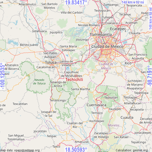
Techichili GPS coordinates[2]
19° 10' 17.004" North, 99° 25' 19.992" West
| Map corner | latitude | longitude |
|---|---|---|
| Upper-left | 19.83417°, | -100.12535° |
| Center: | 19.17139°, | -99.42222° |
| Lower-right: | 18.50593°, | -98.7191° |
| Map W x H: | 147.7×147.7 km | = 91.8×91.8mi |
| max Lat: | 32.7° ⇑61.8% North |
| Techichili: | 19.17139° |
| min Lat: | ⇓38.2% South 14.53588° |
| min Long | Techichili | max Long |
| -117.105° | -99.42222° | -86.73105° |
| W 44.1%⇐ | ⇒55.9% E |
Elevation
Elevation of Techichili is 2802 m = 9193 ft, and this is 1548.3 m = 5080 ft above average elevation for this country.
| Max E: |
3497 m = 11473 ft | 1.4% |
| Techichili | 2802 m 9193 ft | |
| Avg. | 1253.7 m = 4113 ft | |
Min E: |
-1 m = -3 ft | 98.6% |
See also: Mexico elevation on elevation.city.
Geographical zone
Techichili is located in North Torrid zone (between Equator and Tropic of Cancer). Distance of this Northern Tropic circle is 474.3 km =294.7 mi to North.| Distance of | km | miles | from Techichili |
|---|---|---|---|
| North Pole | 7875.4 | 4893.5 | to North |
| Arctic Circle | 5269.5 | 3274.3 | to North |
| Tropic Cancer | 474.3 | 294.7 | to North |
| Equator | 2131.7 | 1324.6 | to South |


Nearby cities:
15 places around Techichili: (largest is in red/bold)
• Coexapa
3 km =1.9 mi,  124°
124°
• Colonia las Granjas
3.2 km =2 mi,  287°
287°
• Cruz Larga
2.5 km =1.6 mi,  78°
78°
• Cuixapa (Coexapa)
2.7 km =1.7 mi, 120°
• El Potrero
2.4 km =1.5 mi,  55°
55°
• El Águila (La Mesa)
1.7 km =1.1 mi,  106°
106°
• La Magdalena de los Reyes (La Magdalena)
2.4 km =1.5 mi,  32°
32°
• Los Tejocotes
2.7 km =1.7 mi, 62°
• Mezapa la Fábrica
2.5 km =1.6 mi,  280°
280°
• Pueblo Nuevo
3.4 km =2.1 mi,  187°
187°
• San Juan Tomasquillo Herradura
1.9 km =1.2 mi,  87°
87°
• Santa Cruz de Bravo (Santa Cruz)
3.4 km =2.1 mi,  17°
17°
• Santa Fe Mezapa
3.3 km =2.1 mi,  249°
249°
• Santiago Tílapa
2 km =1.2 mi,  3°
3°
• Xalatlaco
1.4 km =0.9 mi, 16°
Sources, notices
• [Note1] Compared only with cities in Mexico existing in our database
• [Src1] Map data: © OpenStreetMap contributors (CC-BY-SA)
• [Src2] Other city data from geonames.org with taken over terms of usage.
• [Src3] Geographical zone / Annual Mean Temperature by Robert A. Rohde @ Wikipedia
