Pueblo Nuevo geodata
Pueblo Nuevo (State of Mexico) is a populated place; located in Mexico in America/Mexico_City (GMT-6) time zone. With population of 1,013 people, there are 8605 cities with bigger population in this country. Compared to other cities in Mexico, 62.4% of cities are located further ↑North; 56% of cities are located further →East and 98.4% of cities have lower elevation than Pueblo Nuevo. Note1


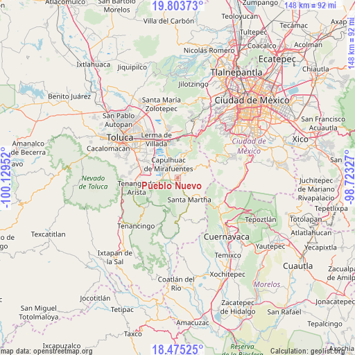
Pueblo Nuevo GPS coordinates[2]
19° 8' 26.988" North, 99° 25' 35.004" West
| Map corner | latitude | longitude |
|---|---|---|
| Upper-left | 19.80373°, | -100.12952° |
| Center: | 19.14083°, | -99.42639° |
| Lower-right: | 18.47525°, | -98.72327° |
| Map W x H: | 147.7×147.7 km | = 91.8×91.8mi |
| max Lat: | 32.7° ⇑62.4% North |
| Pueblo Nuevo: | 19.14083° |
| min Lat: | ⇓37.6% South 14.53588° |
| min Long | Pueblo Nuevo | max Long |
| -117.105° | -99.42639° | -86.73105° |
| W 44%⇐ | ⇒56% E |
Elevation
Elevation of Pueblo Nuevo is 2779 m = 9117 ft, and this is 1525.3 m = 5004 ft above average elevation for this country.
| Max E: |
3497 m = 11473 ft | 1.6% |
| Pueblo Nuevo | 2779 m 9117 ft | |
| Avg. | 1253.7 m = 4113 ft | |
Min E: |
-1 m = -3 ft | 98.4% |
See also: Mexico elevation on elevation.city.
Geographical zone
Pueblo Nuevo is located in North Torrid zone (between Equator and Tropic of Cancer). Distance of this Northern Tropic circle is 477.7 km =296.8 mi to North.| Distance of | km | miles | from Pueblo Nuevo |
|---|---|---|---|
| North Pole | 7878.8 | 4895.7 | to North |
| Arctic Circle | 5272.9 | 3276.4 | to North |
| Tropic Cancer | 477.7 | 296.8 | to North |
| Equator | 2128.3 | 1322.5 | to South |


Nearby cities:
15 places around Pueblo Nuevo: (largest is in red/bold)
• Ahuatenco
3.3 km =2.1 mi,  259°
259°
• Antlantlacpac
1.9 km =1.2 mi,  194°
194°
• Chiquixpac Sección II
1.9 km =1.2 mi,  97°
97°
• Coexapa
3.4 km =2.1 mi,  59°
59°
• Colonia Campesina
3.8 km =2.4 mi,  165°
165°
• Cuixapa (Coexapa)
3.4 km =2.1 mi,  53°
53°
• El Águila (La Mesa)
3.6 km =2.2 mi,  35°
35°
• Metztitla
1.6 km =1 mi, 165°
• San Nicolás Coatepec
0.5 km =0.3 mi,  219°
219°
• Santa Fe Mezapa
3.4 km =2.1 mi,  310°
310°
• Techichili
3.4 km =2.1 mi,  7°
7°
• Techmaninalli
0.7 km =0.4 mi,  94°
94°
• Tlacomulco
3.1 km =1.9 mi,  225°
225°
• Tlacuitlapa
2.4 km =1.5 mi,  150°
150°
• Tlaminca
1.5 km =0.9 mi,  248°
248°
Sources, notices
• [Note1] Compared only with cities in Mexico existing in our database
• [Src1] Map data: © OpenStreetMap contributors (CC-BY-SA)
• [Src2] Other city data from geonames.org with taken over terms of usage.
• [Src3] Geographical zone / Annual Mean Temperature by Robert A. Rohde @ Wikipedia
