La Trinidad geodata
La Trinidad (Guanajuato) is a populated place; located in Mexico in America/Mexico_City (GMT-6) time zone. With population of 1,065 people, there are 8190 cities with bigger population in this country. Compared to other cities in Mexico, 69.2% of cities are located further ↓South; 71.7% of cities are located further →East and 62.3% of cities have lower elevation than La Trinidad. Note1


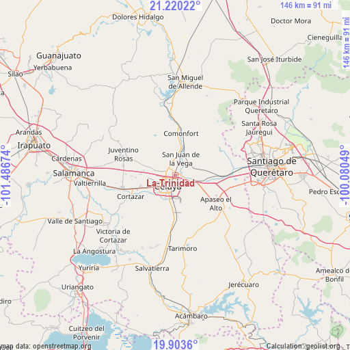
La Trinidad GPS coordinates[2]
20° 33' 47.988" North, 100° 47' 0.996" West
| Map corner | latitude | longitude |
|---|---|---|
| Upper-left | 21.22022°, | -101.48674° |
| Center: | 20.56333°, | -100.78361° |
| Lower-right: | 19.9036°, | -100.08049° |
| Map W x H: | 146.4×146.4 km | = 91×91mi |
| max Lat: | 32.7° ⇑30.8% North |
| La Trinidad: | 20.56333° |
| min Lat: | ⇓69.2% South 14.53588° |
| min Long | La Trinidad | max Long |
| -117.105° | -100.78361° | -86.73105° |
| W 28.3%⇐ | ⇒71.7% E |
Elevation
Elevation of La Trinidad is 1764 m = 5787 ft, and this is 510.3 m = 1674 ft above average elevation for this country.
| Max E: |
3497 m = 11473 ft | 37.7% |
| La Trinidad | 1764 m 5787 ft | |
| Avg. | 1253.7 m = 4113 ft | |
Min E: |
-1 m = -3 ft | 62.3% |
See also: Mexico elevation on elevation.city.
Geographical zone
La Trinidad is located in North Torrid zone (between Equator and Tropic of Cancer). Distance of this Northern Tropic circle is 319.5 km =198.5 mi to North.| Distance of | km | miles | from La Trinidad |
|---|---|---|---|
| North Pole | 7720.6 | 4797.4 | to North |
| Arctic Circle | 5114.7 | 3178.1 | to North |
| Tropic Cancer | 319.5 | 198.5 | to North |
| Equator | 2286.4 | 1420.7 | to South |


Nearby cities:
15 places around La Trinidad: (largest is in red/bold)
• Celaya
5.5 km =3.4 mi,  217°
217°
• Colonia Luis Donaldo Colosio
1.9 km =1.2 mi,  78°
78°
• La Concepción
5.9 km =3.7 mi,  348°
348°
• La Laja
4.4 km =2.7 mi,  148°
148°
• Plancarte
2.9 km =1.8 mi,  333°
333°
• Rancho Nuevo
5.6 km =3.5 mi,  131°
131°
• Roque
6 km =3.7 mi,  290°
290°
• San Antonio Gallardo
7.4 km =4.6 mi,  12°
12°
• San Cayetano
5.9 km =3.7 mi,  319°
319°
• San Isidro de la Concepción
7.2 km =4.5 mi,  358°
358°
• San José de la Presa
6.2 km =3.9 mi,  31°
31°
• San Juan de la Vega
7.3 km =4.5 mi,  18°
18°
• San Luis Rey
0.9 km =0.6 mi,  339°
339°
• San Miguel Octopan
3.9 km =2.4 mi,  71°
71°
• Tenería del Santuario
4.3 km =2.7 mi, 339°
Sources, notices
• [Note1] Compared only with cities in Mexico existing in our database
• [Src1] Map data: © OpenStreetMap contributors (CC-BY-SA)
• [Src2] Other city data from geonames.org with taken over terms of usage.
• [Src3] Geographical zone / Annual Mean Temperature by Robert A. Rohde @ Wikipedia
