San Juan de la Vega geodata
San Juan de la Vega (Guanajuato) is a populated place; located in Mexico in America/Mexico_City (GMT-6) time zone. With population of 9,597 people, there are 997 cities with bigger population in this country. Compared to other cities in Mexico, 70.5% of cities are located further ↓South; 71.6% of cities are located further →East and 62.9% of cities have lower elevation than San Juan de la Vega. Note1


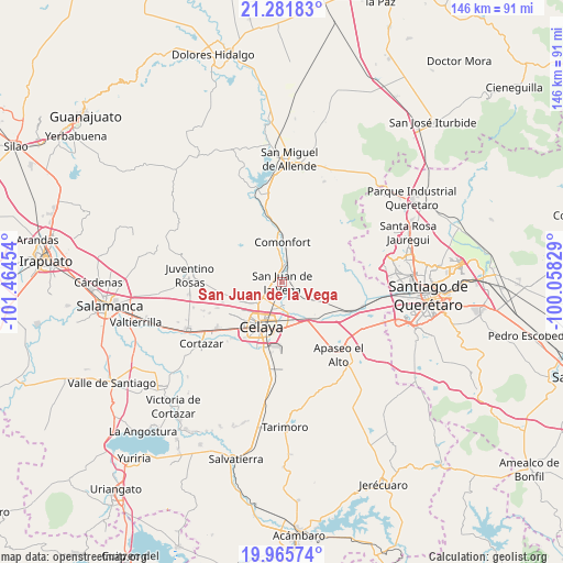
San Juan de la Vega GPS coordinates[2]
20° 37' 30.756" North, 100° 45' 41.076" West
| Map corner | latitude | longitude |
|---|---|---|
| Upper-left | 21.28183°, | -101.46454° |
| Center: | 20.62521°, | -100.76141° |
| Lower-right: | 19.96574°, | -100.05829° |
| Map W x H: | 146.3×146.3 km | = 90.9×90.9mi |
| max Lat: | 32.7° ⇑29.5% North |
| San Juan de la Vega: | 20.62521° |
| min Lat: | ⇓70.5% South 14.53588° |
| min Long | San Juan de la | max Long |
| -117.105° | -100.76141° | -86.73105° |
| W 28.4%⇐ | ⇒71.6% E |
Elevation
Elevation of San Juan de la Vega is 1777 m = 5830 ft, and this is 523.3 m = 1717 ft above average elevation for this country.
| Max E: |
3497 m = 11473 ft | 37.1% |
| San Juan de la Vega | 1777 m 5830 ft | |
| Avg. | 1253.7 m = 4113 ft | |
Min E: |
-1 m = -3 ft | 62.9% |
See also: Mexico elevation on elevation.city.
Geographical zone
San Juan de la Vega is located in North Torrid zone (between Equator and Tropic of Cancer). Distance of this Northern Tropic circle is 312.6 km =194.2 mi to North.| Distance of | km | miles | from San Juan de la Vega |
|---|---|---|---|
| North Pole | 7713.8 | 4793.1 | to North |
| Arctic Circle | 5107.9 | 3173.9 | to North |
| Tropic Cancer | 312.6 | 194.2 | to North |
| Equator | 2293.3 | 1425 | to South |


Nearby cities:
15 places around San Juan de la Vega: (largest is in red/bold)
• Colonia Luis Donaldo Colosio
6.5 km =4 mi,  183°
183°
• Empalme Escobedo
5.5 km =3.4 mi,  16°
16°
• Galvanes
6 km =3.7 mi,  63°
63°
• Guadalupe
3.5 km =2.2 mi, 22°
• Jauregui
5.7 km =3.5 mi,  129°
129°
• La Aurora
0.4 km =0.2 mi,  68°
68°
• La Concepción
3.6 km =2.2 mi,  252°
252°
• Plancarte
5.6 km =3.5 mi,  220°
220°
• Presa Blanca
3.7 km =2.3 mi,  299°
299°
• San Antonio Espinoza
4.7 km =2.9 mi,  310°
310°
• San Antonio Gallardo
0.7 km =0.4 mi, 297°
• San Isidro de la Concepción
2.5 km =1.6 mi,  276°
276°
• San José de la Presa
1.8 km =1.1 mi,  148°
148°
• San Miguel Octopan
5.8 km =3.6 mi,  165°
165°
• Tenería del Santuario
4.7 km =2.9 mi,  233°
233°
Sources, notices
• [Note1] Compared only with cities in Mexico existing in our database
• [Src1] Map data: © OpenStreetMap contributors (CC-BY-SA)
• [Src2] Other city data from geonames.org with taken over terms of usage.
• [Src3] Geographical zone / Annual Mean Temperature by Robert A. Rohde @ Wikipedia
