La Laja geodata
La Laja (Guanajuato) is a populated place; located in Mexico in America/Mexico_City (GMT-6) time zone. With population of 2,075 people, there are 4203 cities with bigger population in this country. Compared to other cities in Mexico, 68.5% of cities are located further ↓South; 71.6% of cities are located further →East and 61.9% of cities have lower elevation than La Laja. Note1


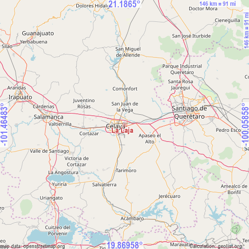
La Laja GPS coordinates[2]
20° 31' 46.056" North, 100° 45' 42.12" West
| Map corner | latitude | longitude |
|---|---|---|
| Upper-left | 21.1865°, | -101.46483° |
| Center: | 20.52946°, | -100.7617° |
| Lower-right: | 19.86958°, | -100.05858° |
| Map W x H: | 146.4×146.4 km | = 91×91mi |
| max Lat: | 32.7° ⇑31.5% North |
| La Laja: | 20.52946° |
| min Lat: | ⇓68.5% South 14.53588° |
| min Long | La Laja | max Long |
| -117.105° | -100.7617° | -86.73105° |
| W 28.4%⇐ | ⇒71.6% E |
Elevation
Elevation of La Laja is 1758 m = 5768 ft, and this is 504.3 m = 1655 ft above average elevation for this country.
| Max E: |
3497 m = 11473 ft | 38.1% |
| La Laja | 1758 m 5768 ft | |
| Avg. | 1253.7 m = 4113 ft | |
Min E: |
-1 m = -3 ft | 61.9% |
See also: Mexico elevation on elevation.city.
Geographical zone
La Laja is located in North Torrid zone (between Equator and Tropic of Cancer). Distance of this Northern Tropic circle is 323.3 km =200.9 mi to North.| Distance of | km | miles | from La Laja |
|---|---|---|---|
| North Pole | 7724.4 | 4799.7 | to North |
| Arctic Circle | 5118.5 | 3180.5 | to North |
| Tropic Cancer | 323.3 | 200.9 | to North |
| Equator | 2282.7 | 1418.4 | to South |


Nearby cities:
15 places around La Laja: (largest is in red/bold)
• Apaseo el Grande
8.2 km =5.1 mi,  77°
77°
• Celaya
5.7 km =3.5 mi,  263°
263°
• Colonia Luis Donaldo Colosio
4.2 km =2.6 mi,  354°
354°
• Estancia del Llano
4.2 km =2.6 mi,  119°
119°
• Juan Martín
6.5 km =4 mi,  166°
166°
• La Labor
6.2 km =3.9 mi,  85°
85°
• La Palma
6.8 km =4.2 mi,  103°
103°
• La Trinidad
4.4 km =2.7 mi,  328°
328°
• Los Mancera
7.9 km =4.9 mi,  213°
213°
• Michinelas
7.5 km =4.7 mi,  221°
221°
• Plancarte
7.3 km =4.5 mi, 330°
• Rancho Nuevo
1.9 km =1.2 mi, 89°
• San Luis Rey
5.2 km =3.2 mi, 330°
• San Miguel Octopan
5.2 km =3.2 mi,  16°
16°
• San Ramón
6.7 km =4.2 mi,  55°
55°
Sources, notices
• [Note1] Compared only with cities in Mexico existing in our database
• [Src1] Map data: © OpenStreetMap contributors (CC-BY-SA)
• [Src2] Other city data from geonames.org with taken over terms of usage.
• [Src3] Geographical zone / Annual Mean Temperature by Robert A. Rohde @ Wikipedia
