San Miguel Octopan geodata
San Miguel Octopan (Guanajuato) is a populated place; located in Mexico in America/Mexico_City (GMT-6) time zone. With population of 13,303 people, there are 737 cities with bigger population in this country. Compared to other cities in Mexico, 69.4% of cities are located further ↓South; 71.4% of cities are located further →East and 62.4% of cities have lower elevation than San Miguel Octopan. Note1


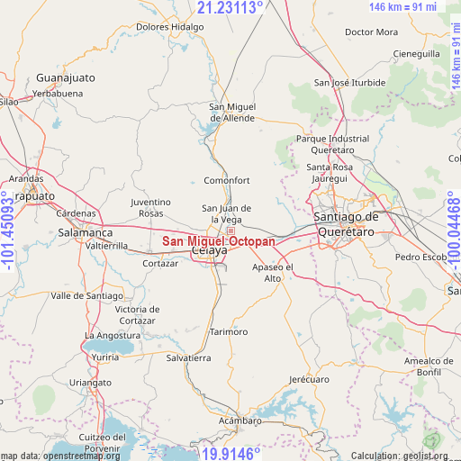
San Miguel Octopan GPS coordinates[2]
20° 34' 27.408" North, 100° 44' 52.08" West
| Map corner | latitude | longitude |
|---|---|---|
| Upper-left | 21.23113°, | -101.45093° |
| Center: | 20.57428°, | -100.7478° |
| Lower-right: | 19.9146°, | -100.04468° |
| Map W x H: | 146.4×146.4 km | = 91×91mi |
| max Lat: | 32.7° ⇑30.6% North |
| San Miguel Octopan: | 20.57428° |
| min Lat: | ⇓69.4% South 14.53588° |
| min Long | San Miguel Octo | max Long |
| -117.105° | -100.7478° | -86.73105° |
| W 28.6%⇐ | ⇒71.4% E |
Elevation
Elevation of San Miguel Octopan is 1767 m = 5797 ft, and this is 513.3 m = 1684 ft above average elevation for this country.
| Max E: |
3497 m = 11473 ft | 37.6% |
| San Miguel Octopan | 1767 m 5797 ft | |
| Avg. | 1253.7 m = 4113 ft | |
Min E: |
-1 m = -3 ft | 62.4% |
See also: Mexico elevation on elevation.city.
Geographical zone
San Miguel Octopan is located in North Torrid zone (between Equator and Tropic of Cancer). Distance of this Northern Tropic circle is 318.3 km =197.8 mi to North.| Distance of | km | miles | from San Miguel Octopan |
|---|---|---|---|
| North Pole | 7719.4 | 4796.6 | to North |
| Arctic Circle | 5113.5 | 3177.4 | to North |
| Tropic Cancer | 318.3 | 197.8 | to North |
| Equator | 2287.6 | 1421.4 | to South |


Nearby cities:
15 places around San Miguel Octopan: (largest is in red/bold)
• Colonia Luis Donaldo Colosio
2 km =1.2 mi,  245°
245°
• Jauregui
3.6 km =2.2 mi,  55°
55°
• Jocoqui
5.2 km =3.2 mi,  80°
80°
• La Aurora
5.9 km =3.7 mi,  350°
350°
• La Labor
6.6 km =4.1 mi,  133°
133°
• La Laja
5.2 km =3.2 mi,  196°
196°
• La Trinidad
3.9 km =2.4 mi, 251°
• Plancarte
5.2 km =3.2 mi,  285°
285°
• Rancho Nuevo
5 km =3.1 mi,  174°
174°
• San Antonio Gallardo
6.4 km =4 mi,  340°
340°
• San José de la Presa
4.1 km =2.5 mi, 353°
• San Juan de la Vega
5.8 km =3.6 mi, 345°
• San Luis Rey
4 km =2.5 mi,  264°
264°
• San Ramón
4.3 km =2.7 mi,  105°
105°
• Tenería del Santuario
5.9 km =3.7 mi,  298°
298°
Sources, notices
• [Note1] Compared only with cities in Mexico existing in our database
• [Src1] Map data: © OpenStreetMap contributors (CC-BY-SA)
• [Src2] Other city data from geonames.org with taken over terms of usage.
• [Src3] Geographical zone / Annual Mean Temperature by Robert A. Rohde @ Wikipedia
