San Bartolomé Coatepec geodata
San Bartolomé Coatepec (State of Mexico) is a populated place; located in Mexico in America/Mexico_City (GMT-6) time zone. With population of 5,021 people, there are 1838 cities with bigger population in this country. Compared to other cities in Mexico, 56.4% of cities are located further ↑North; 54.3% of cities are located further →East and 91.8% of cities have lower elevation than San Bartolomé Coatepec. Note1
Current local time in San Bartolomé Coatepec:
07:17 AM, TuesdayDifference from your time zone: hours


San Bartolomé Coatepec GPS coordinates[2]
19° 23' 51.936" North, 99° 18' 43.596" West
| Map corner | latitude | longitude |
|---|---|---|
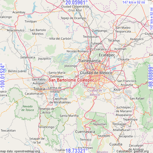
| Upper-left | 20.05961°, | -100.01524° |
| Center: | 19.39776°, | -99.31211° |
| Lower-right: | 18.73321°, | -98.60899° |
| Map W x H: | 147.5×147.5 km | = 91.7×91.7mi |
| max Lat: | 32.7° ⇑56.4% North |
| San Bartolomé Coatepec: | 19.39776° |
| min Lat: | ⇓43.6% South 14.53588° |
| min Long | San Bartolomé | max Long |
| -117.105° | -99.31211° | -86.73105° |
| W 45.7%⇐ | ⇒54.3% E |
Elevation
Elevation of San Bartolomé Coatepec is 2473 m = 8114 ft, and this is 1219.3 m = 4000 ft above average elevation for this country.
| Max E: |
3497 m = 11473 ft | 8.2% |
| San Bartolomé Coatepec | 2473 m 8114 ft | |
| Avg. | 1253.7 m = 4113 ft | |
Min E: |
-1 m = -3 ft | 91.8% |
See also: Mexico elevation on elevation.city.
Geographical zone
San Bartolomé Coatepec is located in North Torrid zone (between Equator and Tropic of Cancer). Distance of this Northern Tropic circle is 449.1 km =279.1 mi to North.| Distance of | km | miles | from San Bartolomé Coatepec |
|---|---|---|---|
| North Pole | 7850.2 | 4877.9 | to North |
| Arctic Circle | 5244.3 | 3258.7 | to North |
| Tropic Cancer | 449.1 | 279.1 | to North |
| Equator | 2156.8 | 1340.2 | to South |


Nearby cities:
15 places around San Bartolomé Coatepec: (largest is in red/bold)
• Arenal
2 km =1.2 mi,  33°
33°
• Barrio de San Ramón
3.3 km =2.1 mi,  216°
216°
• Barrio la Manzana (La Rinconada)
4 km =2.5 mi,  319°
319°
• Delegación Cuajimalpa de Morelos
3.9 km =2.4 mi,  144°
144°
• Dos Ríos
4.2 km =2.6 mi,  232°
232°
• Ejido el Castillo
4.3 km =2.7 mi,  8°
8°
• Huiloteapan (San José Huiloteapan)
3.9 km =2.4 mi,  249°
249°
• Jesús del Monte
3.1 km =1.9 mi, 143°
• La Magdalena Chichicaspa
2.2 km =1.4 mi, 319°
• Llano de las Flores (Barrio del Hueso)
4.4 km =2.7 mi,  345°
345°
• Paraje Trejo (El Chaparral)
0.9 km =0.6 mi,  359°
359°
• Paraje el Mirador
1.6 km =1 mi,  276°
276°
• Paraje la Pera
3.9 km =2.4 mi,  240°
240°
• San Jacinto
4 km =2.5 mi,  196°
196°
• Santiago Yancuitlalpan
1.7 km =1.1 mi,  153°
153°
Sources, notices
• [Note1] Compared only with cities in Mexico existing in our database
• [Src1] Map data: © OpenStreetMap contributors (CC-BY-SA)
• [Src2] Other city data from geonames.org with taken over terms of usage.
• [Src3] Geographical zone / Annual Mean Temperature by Robert A. Rohde @ Wikipedia
