Paraje Trejo (El Chaparral) geodata
Paraje Trejo (El Chaparral) (State of Mexico) is a populated place; located in Mexico in America/Mexico_City (GMT-6) time zone. With population of 1,062 people, there are 8219 cities with bigger population in this country. Compared to other cities in Mexico, 56.2% of cities are located further ↑North; 54.3% of cities are located further →East and 93.7% of cities have lower elevation than Paraje Trejo (El Chaparral). Note1
Current local time in Paraje Trejo (El Chaparral):
05:27 AM, WednesdayDifference from your time zone: hours


Paraje Trejo (El Chaparral) GPS coordinates[2]
19° 24' 20.016" North, 99° 18' 43.992" West
| Map corner | latitude | longitude |
|---|---|---|
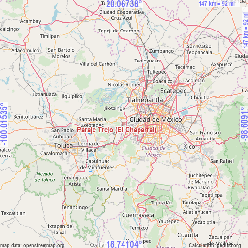
| Upper-left | 20.06738°, | -100.01535° |
| Center: | 19.40556°, | -99.31222° |
| Lower-right: | 18.74104°, | -98.6091° |
| Map W x H: | 147.5×147.5 km | = 91.7×91.7mi |
| max Lat: | 32.7° ⇑56.2% North |
| Paraje Trejo (El Chaparral): | 19.40556° |
| min Lat: | ⇓43.8% South 14.53588° |
| min Long | Paraje Trejo (E | max Long |
| -117.105° | -99.31222° | -86.73105° |
| W 45.7%⇐ | ⇒54.3% E |
Elevation
Elevation of Paraje Trejo (El Chaparral) is 2556 m = 8386 ft, and this is 1302.3 m = 4273 ft above average elevation for this country.
| Max E: |
3497 m = 11473 ft | 6.3% |
| Paraje Trejo (El Chaparral) | 2556 m 8386 ft | |
| Avg. | 1253.7 m = 4113 ft | |
Min E: |
-1 m = -3 ft | 93.7% |
See also: Mexico elevation on elevation.city.
Geographical zone
Paraje Trejo (El Chaparral) is located in North Torrid zone (between Equator and Tropic of Cancer). Distance of this Northern Tropic circle is 448.2 km =278.5 mi to North.| Distance of | km | miles | from Paraje Trejo (El Chaparral) |
|---|---|---|---|
| North Pole | 7849.4 | 4877.4 | to North |
| Arctic Circle | 5243.5 | 3258.2 | to North |
| Tropic Cancer | 448.2 | 278.5 | to North |
| Equator | 2157.7 | 1340.7 | to South |


Nearby cities:
15 places around Paraje Trejo (El Chaparral): (largest is in red/bold)
• Arenal
1.4 km =0.9 mi,  54°
54°
• Barrio de San Ramón
4.1 km =2.5 mi,  209°
209°
• Barrio la Manzana (La Rinconada)
3.4 km =2.1 mi,  309°
309°
• Delegación Cuajimalpa de Morelos
4.6 km =2.9 mi,  151°
151°
• Dos Ríos
4.8 km =3 mi,  223°
223°
• Ejido el Castillo
3.4 km =2.1 mi,  11°
11°
• Huiloteapan (San José Huiloteapan)
4.3 km =2.7 mi,  238°
238°
• Jesús del Monte
3.9 km =2.4 mi, 151°
• La Magdalena Chichicaspa
1.6 km =1 mi,  298°
298°
• Llano de las Flores (Barrio del Hueso)
3.5 km =2.2 mi,  342°
342°
• Paraje el Mirador
1.7 km =1.1 mi,  246°
246°
• Paraje la Pera
4.4 km =2.7 mi,  231°
231°
• San Bartolomé Coatepec
0.9 km =0.6 mi,  179°
179°
• San Jacinto
4.9 km =3 mi,  193°
193°
• Santiago Yancuitlalpan
2.5 km =1.6 mi,  161°
161°
Sources, notices
• [Note1] Compared only with cities in Mexico existing in our database
• [Src1] Map data: © OpenStreetMap contributors (CC-BY-SA)
• [Src2] Other city data from geonames.org with taken over terms of usage.
• [Src3] Geographical zone / Annual Mean Temperature by Robert A. Rohde @ Wikipedia
