Arenal geodata
Arenal (State of Mexico) is a populated place; located in Mexico in America/Mexico_City (GMT-6) time zone. With population of 554 people, there are 15392 cities with bigger population in this country. Compared to other cities in Mexico, 56% of cities are located further ↑North; 54.2% of cities are located further →East and 93.4% of cities have lower elevation than Arenal. Note1


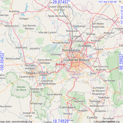
Arenal GPS coordinates[2]
19° 24' 46.008" North, 99° 18' 5.004" West
| Map corner | latitude | longitude |
|---|---|---|
| Upper-left | 20.07457°, | -100.00452° |
| Center: | 19.41278°, | -99.30139° |
| Lower-right: | 18.74829°, | -98.59827° |
| Map W x H: | 147.5×147.5 km | = 91.7×91.7mi |
| max Lat: | 32.7° ⇑56% North |
| Arenal: | 19.41278° |
| min Lat: | ⇓44% South 14.53588° |
| min Long | Arenal | max Long |
| -117.105° | -99.30139° | -86.73105° |
| W 45.8%⇐ | ⇒54.2% E |
Elevation
Elevation of Arenal is 2548 m = 8360 ft, and this is 1294.3 m = 4246 ft above average elevation for this country.
| Max E: |
3497 m = 11473 ft | 6.6% |
| Arenal | 2548 m 8360 ft | |
| Avg. | 1253.7 m = 4113 ft | |
Min E: |
-1 m = -3 ft | 93.4% |
See also: Mexico elevation on elevation.city.
Geographical zone
Arenal is located in North Torrid zone (between Equator and Tropic of Cancer). Distance of this Northern Tropic circle is 447.4 km =278 mi to North.| Distance of | km | miles | from Arenal |
|---|---|---|---|
| North Pole | 7848.6 | 4876.9 | to North |
| Arctic Circle | 5242.7 | 3257.7 | to North |
| Tropic Cancer | 447.4 | 278 | to North |
| Equator | 2158.5 | 1341.2 | to South |


Nearby cities:
15 places around Arenal: (largest is in red/bold)
• Barrio de San Ramón
5.4 km =3.4 mi,  215°
215°
• Barrio la Manzana (La Rinconada)
4 km =2.5 mi,  290°
290°
• Barrio las Salinas
5.2 km =3.2 mi,  302°
302°
• Col. Bosques de las Lomas
5.3 km =3.3 mi,  135°
135°
• Delegación Cuajimalpa de Morelos
5 km =3.1 mi,  167°
167°
• Ejido el Castillo
2.6 km =1.6 mi,  349°
349°
• Huiloteapan (San José Huiloteapan)
5.7 km =3.5 mi,  237°
237°
• Jesús del Monte
4.3 km =2.7 mi, 170°
• La Magdalena Chichicaspa
2.5 km =1.6 mi,  268°
268°
• Llano de las Flores (Barrio del Hueso)
3.4 km =2.1 mi,  319°
319°
• Paraje Trejo (El Chaparral)
1.4 km =0.9 mi,  234°
234°
• Paraje el Mirador
3.1 km =1.9 mi, 241°
• San Bartolomé Coatepec
2 km =1.2 mi,  213°
213°
• San Francisco Chimalpa
5.6 km =3.5 mi,  306°
306°
• Santiago Yancuitlalpan
3.2 km =2 mi,  186°
186°
Sources, notices
• [Note1] Compared only with cities in Mexico existing in our database
• [Src1] Map data: © OpenStreetMap contributors (CC-BY-SA)
• [Src2] Other city data from geonames.org with taken over terms of usage.
• [Src3] Geographical zone / Annual Mean Temperature by Robert A. Rohde @ Wikipedia
