Tlaminca geodata
Tlaminca (State of Mexico) is a populated place; located in Mexico in America/Mexico_City (GMT-6) time zone. With population of 1,007 people, there are 8660 cities with bigger population in this country. Compared to other cities in Mexico, 62.5% of cities are located further ↑North; 56.1% of cities are located further →East and 97.4% of cities have lower elevation than Tlaminca. Note1


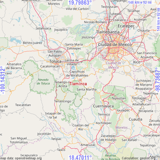
Tlaminca GPS coordinates[2]
19° 8' 8.556" North, 99° 26' 23.964" West
| Map corner | latitude | longitude |
|---|---|---|
| Upper-left | 19.79863°, | -100.14312° |
| Center: | 19.13571°, | -99.43999° |
| Lower-right: | 18.47011°, | -98.73687° |
| Map W x H: | 147.7×147.7 km | = 91.8×91.8mi |
| max Lat: | 32.7° ⇑62.5% North |
| Tlaminca: | 19.13571° |
| min Lat: | ⇓37.5% South 14.53588° |
| min Long | Tlaminca | max Long |
| -117.105° | -99.43999° | -86.73105° |
| W 43.9%⇐ | ⇒56.1% E |
Elevation
Elevation of Tlaminca is 2708 m = 8885 ft, and this is 1454.3 m = 4771 ft above average elevation for this country.
| Max E: |
3497 m = 11473 ft | 2.6% |
| Tlaminca | 2708 m 8885 ft | |
| Avg. | 1253.7 m = 4113 ft | |
Min E: |
-1 m = -3 ft | 97.4% |
See also: Mexico elevation on elevation.city.
Geographical zone
Tlaminca is located in North Torrid zone (between Equator and Tropic of Cancer). Distance of this Northern Tropic circle is 478.2 km =297.1 mi to North.| Distance of | km | miles | from Tlaminca |
|---|---|---|---|
| North Pole | 7879.4 | 4896 | to North |
| Arctic Circle | 5273.5 | 3276.8 | to North |
| Tropic Cancer | 478.2 | 297.1 | to North |
| Equator | 2127.7 | 1322.1 | to South |


Nearby cities:
15 places around Tlaminca: (largest is in red/bold)
• Ahuatenco
1.8 km =1.1 mi,  269°
269°
• Antlantlacpac
1.6 km =1 mi,  141°
141°
• Chiquixpac Sección II
3.3 km =2.1 mi,  84°
84°
• Colonia Campesina
3.9 km =2.4 mi, 142°
• Metztitla
2 km =1.2 mi,  117°
117°
• Pueblo Nuevo
1.5 km =0.9 mi,  68°
68°
• San José Mezapa Sección I
3.4 km =2.1 mi,  332°
332°
• San Lorenzo Huehuetitlán
4.4 km =2.7 mi, 267°
• San Mateo Texcalyacac
4.4 km =2.7 mi,  320°
320°
• San Nicolás Coatepec
1.1 km =0.7 mi, 80°
• Santa Fe Mezapa
3 km =1.9 mi,  336°
336°
• Techichili
4.4 km =2.7 mi,  25°
25°
• Techmaninalli
2.2 km =1.4 mi, 76°
• Tlacomulco
1.8 km =1.1 mi,  205°
205°
• Tlacuitlapa
3 km =1.9 mi, 120°
Sources, notices
• [Note1] Compared only with cities in Mexico existing in our database
• [Src1] Map data: © OpenStreetMap contributors (CC-BY-SA)
• [Src2] Other city data from geonames.org with taken over terms of usage.
• [Src3] Geographical zone / Annual Mean Temperature by Robert A. Rohde @ Wikipedia
