Chiquixpac Sección II geodata
Chiquixpac Sección II (State of Mexico) is a populated place; located in Mexico in America/Mexico_City (GMT-6) time zone. With population of 654 people, there are 13268 cities with bigger population in this country. Compared to other cities in Mexico, 62.4% of cities are located further ↑North; 55.7% of cities are located further →East and 99% of cities have lower elevation than Chiquixpac Sección II. Note1


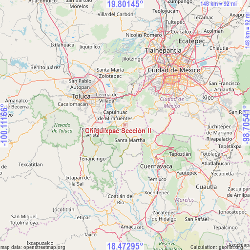
Chiquixpac Sección II GPS coordinates[2]
19° 8' 18.744" North, 99° 24' 30.708" West
| Map corner | latitude | longitude |
|---|---|---|
| Upper-left | 19.80145°, | -100.11166° |
| Center: | 19.13854°, | -99.40853° |
| Lower-right: | 18.47295°, | -98.70541° |
| Map W x H: | 147.7×147.7 km | = 91.8×91.8mi |
| max Lat: | 32.7° ⇑62.4% North |
| Chiquixpac Sección II: | 19.13854° |
| min Lat: | ⇓37.6% South 14.53588° |
| min Long | Chiquixpac Secc | max Long |
| -117.105° | -99.40853° | -86.73105° |
| W 44.3%⇐ | ⇒55.7% E |
Elevation
Elevation of Chiquixpac Sección II is 2839 m = 9314 ft, and this is 1585.3 m = 5201 ft above average elevation for this country.
| Max E: |
3497 m = 11473 ft | 1% |
| Chiquixpac Sección II | 2839 m 9314 ft | |
| Avg. | 1253.7 m = 4113 ft | |
Min E: |
-1 m = -3 ft | 99% |
See also: Mexico elevation on elevation.city.
Geographical zone
Chiquixpac Sección II is located in North Torrid zone (between Equator and Tropic of Cancer). Distance of this Northern Tropic circle is 477.9 km =297 mi to North.| Distance of | km | miles | from Chiquixpac Sección II |
|---|---|---|---|
| North Pole | 7879.1 | 4895.8 | to North |
| Arctic Circle | 5273.2 | 3276.6 | to North |
| Tropic Cancer | 477.9 | 297 | to North |
| Equator | 2128 | 1322.3 | to South |


Nearby cities:
15 places around Chiquixpac Sección II: (largest is in red/bold)
• Antlantlacpac
2.8 km =1.7 mi,  236°
236°
• Coexapa
2.2 km =1.4 mi,  27°
27°
• Colonia Campesina
3.6 km =2.2 mi,  194°
194°
• Cruz Larga
4.3 km =2.7 mi,  13°
13°
• Cuixapa (Coexapa)
2.5 km =1.6 mi,  20°
20°
• El Águila (La Mesa)
3.2 km =2 mi,  4°
4°
• Metztitla
2 km =1.2 mi,  229°
229°
• Pueblo Nuevo
1.9 km =1.2 mi,  277°
277°
• San Bartolo del Progreso
4.1 km =2.5 mi,  173°
173°
• San Juan Tomasquillo Herradura
3.8 km =2.4 mi, 7°
• San Nicolás Coatepec
2.2 km =1.4 mi,  266°
266°
• Techichili
3.9 km =2.4 mi,  338°
338°
• Techmaninalli
1.2 km =0.7 mi, 279°
• Tlacuitlapa
2 km =1.2 mi,  201°
201°
• Tlaminca
3.3 km =2.1 mi,  264°
264°
Sources, notices
• [Note1] Compared only with cities in Mexico existing in our database
• [Src1] Map data: © OpenStreetMap contributors (CC-BY-SA)
• [Src2] Other city data from geonames.org with taken over terms of usage.
• [Src3] Geographical zone / Annual Mean Temperature by Robert A. Rohde @ Wikipedia
