El Edén geodata
El Edén (Chiapas) is a populated place; located in Mexico in America/Mexico_City (GMT-6) time zone. With population of 765 people, there are 11448 cities with bigger population in this country. Compared to other cities in Mexico, 99.3% of cities are located further ↑North; 93.4% of cities are located further ←West and 67.5% of cities have higher elevation than El Edén. Note1


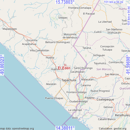
El Edén GPS coordinates[2]
15° 3' 36.54" North, 92° 18' 0.36" West
| Map corner | latitude | longitude |
|---|---|---|
| Upper-left | 15.73803°, | -93.00323° |
| Center: | 15.06015°, | -92.3001° |
| Lower-right: | 14.38011°, | -91.59698° |
| Map W x H: | 151×151 km | = 93.8×93.8mi |
| max Lat: | 32.7° ⇑99.3% North |
| El Edén: | 15.06015° |
| min Lat: | ⇓0.7% South 14.53588° |
| min Long | El Edén | max Long |
| -117.105° | -92.3001° | -86.73105° |
| W 93.4%⇐ | ⇒6.6% E |
Elevation
Elevation of El Edén is 556 m = 1824 ft, and this is 697.7 m = 2289 ft below average elevation for this country.
| Max E: |
3497 m = 11473 ft | 67.5% |
| Avg. | 1253.7 m = 4113 ft | |
| El Edén | 556 m = 1824 ft | |
Min E: |
-1 m = -3 ft | 32.5% |
See also: Mexico elevation on elevation.city.
Geographical zone
El Edén is located in North Torrid zone (between Equator and Tropic of Cancer). Distance of this Northern Tropic circle is 931.4 km =578.7 mi to North.| Distance of | km | miles | from El Edén |
|---|---|---|---|
| North Pole | 8332.5 | 5177.6 | to North |
| Arctic Circle | 5726.6 | 3558.3 | to North |
| Tropic Cancer | 931.4 | 578.7 | to North |
| Equator | 1674.5 | 1040.5 | to South |


Nearby cities:
15 places around El Edén: (largest is in red/bold)
• 26 de Octubre
5.8 km =3.6 mi,  62°
62°
• Cantón Villaflor
8.2 km =5.1 mi,  316°
316°
• Chamulapita
7.5 km =4.7 mi,  277°
277°
• Fracción Galeras
7.5 km =4.7 mi,  95°
95°
• Fracción las Palmas
7.3 km =4.5 mi, 103°
• Guadalupe
9.8 km =6.1 mi,  205°
205°
• Huehuetán
9.9 km =6.2 mi,  243°
243°
• Independencia
1.6 km =1 mi, 97°
• Nueva Granada
8.7 km =5.4 mi,  168°
168°
• San Antonio Chicharras
7 km =4.3 mi, 61°
• Toluca
7 km =4.3 mi,  120°
120°
• Unión Roja
9.1 km =5.7 mi, 99°
• Veinte de Noviembre
9.9 km =6.2 mi,  157°
157°
• Villa Hidalgo
9.5 km =5.9 mi,  303°
303°
• Zaragoza
7.9 km =4.9 mi,  355°
355°
Sources, notices
• [Note1] Compared only with cities in Mexico existing in our database
• [Src1] Map data: © OpenStreetMap contributors (CC-BY-SA)
• [Src2] Other city data from geonames.org with taken over terms of usage.
• [Src3] Geographical zone / Annual Mean Temperature by Robert A. Rohde @ Wikipedia
