Viborillas de Hidalgo geodata
Viborillas de Hidalgo (Puebla) is a populated place; located in Mexico in America/Mexico_City (GMT-6) time zone. With population of 981 people, there are 8862 cities with bigger population in this country. Compared to other cities in Mexico, 72.7% of cities are located further ↑North; 56.4% of cities are located further ←West and 57.1% of cities have higher elevation than Viborillas de Hidalgo. Note1


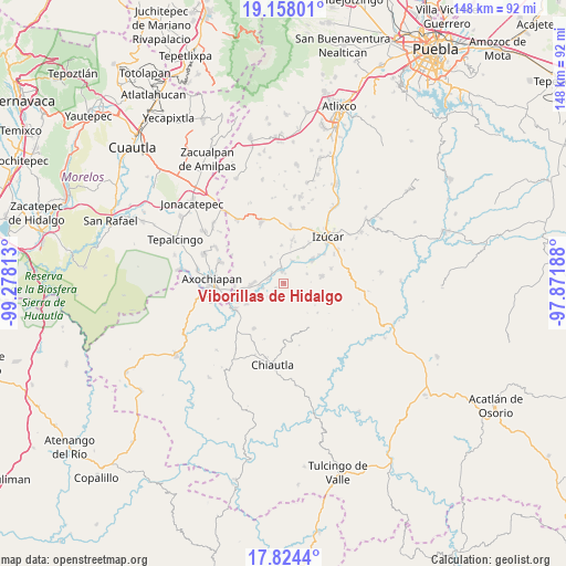
Viborillas de Hidalgo GPS coordinates[2]
18° 29' 33" North, 98° 34' 30" West
| Map corner | latitude | longitude |
|---|---|---|
| Upper-left | 19.15801°, | -99.27813° |
| Center: | 18.4925°, | -98.575° |
| Lower-right: | 17.8244°, | -97.87188° |
| Map W x H: | 148.3×148.3 km | = 92.1×92.1mi |
| max Lat: | 32.7° ⇑72.7% North |
| Viborillas de Hidalgo: | 18.4925° |
| min Lat: | ⇓27.3% South 14.53588° |
| min Long | Viborillas de H | max Long |
| -117.105° | -98.575° | -86.73105° |
| W 56.4%⇐ | ⇒43.6% E |
Elevation
Elevation of Viborillas de Hidalgo is 1120 m = 3675 ft, and this is 133.7 m = 439 ft below average elevation for this country.
| Max E: |
3497 m = 11473 ft | 57.1% |
| Avg. | 1253.7 m = 4113 ft | |
| Viborillas de Hidalgo | 1120 m = 3675 ft | |
Min E: |
-1 m = -3 ft | 42.9% |
See also: Mexico elevation on elevation.city.
Geographical zone
Viborillas de Hidalgo is located in North Torrid zone (between Equator and Tropic of Cancer). Distance of this Northern Tropic circle is 549.7 km =341.6 mi to North.| Distance of | km | miles | from Viborillas de Hidalgo |
|---|---|---|---|
| North Pole | 7950.9 | 4940.5 | to North |
| Arctic Circle | 5345 | 3321.2 | to North |
| Tropic Cancer | 549.7 | 341.6 | to North |
| Equator | 2056.2 | 1277.7 | to South |


Nearby cities:
15 places around Viborillas de Hidalgo: (largest is in red/bold)
• Ahuehuetzingo
6.4 km =4 mi,  264°
264°
• Atencingo
4 km =2.5 mi,  306°
306°
• Atzala
6.4 km =4 mi,  21°
21°
• Ayutla
9.4 km =5.8 mi,  51°
51°
• Buenavista de Benito Juárez
7.5 km =4.7 mi,  241°
241°
• Chietla
3.1 km =1.9 mi,  352°
352°
• Don Roque
5.7 km =3.5 mi, 255°
• Pueblo Nuevo de Porfirio Díaz
3 km =1.9 mi,  42°
42°
• San Carlos
6.5 km =4 mi,  68°
68°
• San Isidro el Organal
7 km =4.3 mi, 314°
• San Juan Colón
9.6 km =6 mi,  10°
10°
• San Miguel la Toma
3.6 km =2.2 mi,  358°
358°
• San Nicolás Tenexcalco
2.6 km =1.6 mi, 240°
• San Nicolás Tolentino
9.9 km =6.2 mi, 49°
• Temaxcalapa de Gabino Barreda
7.6 km =4.7 mi,  334°
334°
Sources, notices
• [Note1] Compared only with cities in Mexico existing in our database
• [Src1] Map data: © OpenStreetMap contributors (CC-BY-SA)
• [Src2] Other city data from geonames.org with taken over terms of usage.
• [Src3] Geographical zone / Annual Mean Temperature by Robert A. Rohde @ Wikipedia
