Huejotengo (San Marcos) geodata
Huejotengo (San Marcos) (Morelos) is a populated place; located in Mexico in America/Mexico_City (GMT-6) time zone. With population of 979 people, there are 8884 cities with bigger population in this country. Compared to other cities in Mexico, 67.1% of cities are located further ↑North; 54.3% of cities are located further ←West and 81.4% of cities have lower elevation than Huejotengo (San Marcos). Note1
Current local time in Huejotengo (San Marcos):
08:27 AM, WednesdayDifference from your time zone: hours


Huejotengo (San Marcos) GPS coordinates[2]
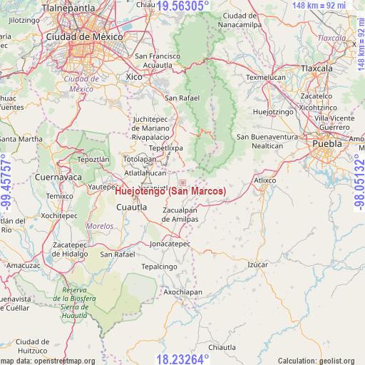
18° 53' 57.012" North, 98° 45' 15.984" West
| Map corner | latitude | longitude |
|---|---|---|
| Upper-left | 19.56305°, | -99.45757° |
| Center: | 18.89917°, | -98.75444° |
| Lower-right: | 18.23264°, | -98.05132° |
| Map W x H: | 147.9×147.9 km | = 91.9×91.9mi |
| max Lat: | 32.7° ⇑67.1% North |
| Huejotengo (San Marcos): | 18.89917° |
| min Lat: | ⇓32.9% South 14.53588° |
| min Long | Huejotengo (San | max Long |
| -117.105° | -98.75444° | -86.73105° |
| W 54.3%⇐ | ⇒45.7% E |
Elevation
Elevation of Huejotengo (San Marcos) is 2173 m = 7129 ft, and this is 919.3 m = 3016 ft above average elevation for this country.
| Max E: |
3497 m = 11473 ft | 18.6% |
| Huejotengo (San Marcos) | 2173 m 7129 ft | |
| Avg. | 1253.7 m = 4113 ft | |
Min E: |
-1 m = -3 ft | 81.4% |
See also: Mexico elevation on elevation.city.
Geographical zone
Huejotengo (San Marcos) is located in North Torrid zone (between Equator and Tropic of Cancer). Distance of this Northern Tropic circle is 504.5 km =313.5 mi to North.| Distance of | km | miles | from Huejotengo (San Marcos) |
|---|---|---|---|
| North Pole | 7905.7 | 4912.4 | to North |
| Arctic Circle | 5299.8 | 3293.1 | to North |
| Tropic Cancer | 504.5 | 313.5 | to North |
| Equator | 2101.4 | 1305.7 | to South |


Nearby cities:
15 places around Huejotengo (San Marcos): (largest is in red/bold)
• Ecatzingo de Hidalgo
6.2 km =3.9 mi,  2°
2°
• Huecahuasco
5.1 km =3.2 mi,  324°
324°
• Huepalcalco (San Miguel)
1.2 km =0.7 mi,  23°
23°
• Hueyapan
7.7 km =4.8 mi,  97°
97°
• Jumiltepec
2.8 km =1.7 mi,  304°
304°
• Metepec
2.4 km =1.5 mi,  160°
160°
• Ocoxaltepec
4 km =2.5 mi, 2°
• Ocuituco
3.1 km =1.9 mi,  219°
219°
• San Antonio Alpanocan
5.2 km =3.2 mi,  118°
118°
• San Francisco Tepango
8.8 km =5.5 mi,  141°
141°
• San Juan Tlacotompa (Tlacotompa)
6 km =3.7 mi, 320°
• San Marcos Tecomaxusco
9.2 km =5.7 mi,  356°
356°
• Tetela del Volcán
2.7 km =1.7 mi, 104°
• Texcala
5.8 km =3.6 mi,  312°
312°
• Xochitlán
6.2 km =3.9 mi,  259°
259°
Sources, notices
• [Note1] Compared only with cities in Mexico existing in our database
• [Src1] Map data: © OpenStreetMap contributors (CC-BY-SA)
• [Src2] Other city data from geonames.org with taken over terms of usage.
• [Src3] Geographical zone / Annual Mean Temperature by Robert A. Rohde @ Wikipedia
