Huepalcalco (San Miguel) geodata
Huepalcalco (San Miguel) (Morelos) is a populated place; located in Mexico in America/Mexico_City (GMT-6) time zone. With population of 1,094 people, there are 7947 cities with bigger population in this country. Compared to other cities in Mexico, 66.8% of cities are located further ↑North; 54.4% of cities are located further ←West and 86.2% of cities have lower elevation than Huepalcalco (San Miguel). Note1
Current local time in Huepalcalco (San Miguel):
12:29 PM, MondayDifference from your time zone: hours


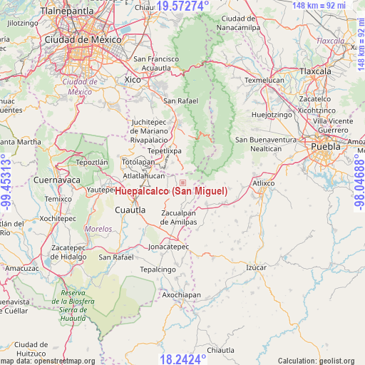
Huepalcalco (San Miguel) GPS coordinates[2]
18° 54' 32.004" North, 98° 45' 0" West
| Map corner | latitude | longitude |
|---|---|---|
| Upper-left | 19.57274°, | -99.45313° |
| Center: | 18.90889°, | -98.75° |
| Lower-right: | 18.2424°, | -98.04688° |
| Map W x H: | 147.9×147.9 km | = 91.9×91.9mi |
| max Lat: | 32.7° ⇑66.8% North |
| Huepalcalco (San Miguel): | 18.90889° |
| min Lat: | ⇓33.2% South 14.53588° |
| min Long | Huepalcalco (Sa | max Long |
| -117.105° | -98.75° | -86.73105° |
| W 54.4%⇐ | ⇒45.6% E |
Elevation
Elevation of Huepalcalco (San Miguel) is 2286 m = 7500 ft, and this is 1032.3 m = 3387 ft above average elevation for this country.
| Max E: |
3497 m = 11473 ft | 13.8% |
| Huepalcalco (San Miguel) | 2286 m 7500 ft | |
| Avg. | 1253.7 m = 4113 ft | |
Min E: |
-1 m = -3 ft | 86.2% |
See also: Mexico elevation on elevation.city.
Geographical zone
Huepalcalco (San Miguel) is located in North Torrid zone (between Equator and Tropic of Cancer). Distance of this Northern Tropic circle is 503.4 km =312.8 mi to North.| Distance of | km | miles | from Huepalcalco (San Miguel) |
|---|---|---|---|
| North Pole | 7904.6 | 4911.7 | to North |
| Arctic Circle | 5298.7 | 3292.5 | to North |
| Tropic Cancer | 503.4 | 312.8 | to North |
| Equator | 2102.5 | 1306.4 | to South |


Nearby cities:
15 places around Huepalcalco (San Miguel): (largest is in red/bold)
• Ecatzingo de Hidalgo
5.1 km =3.2 mi,  357°
357°
• Huecahuasco
4.6 km =2.9 mi,  312°
312°
• Huejotengo (San Marcos)
1.2 km =0.7 mi,  203°
203°
• Hueyapan
7.5 km =4.7 mi,  106°
106°
• Jumiltepec
2.9 km =1.8 mi,  280°
280°
• Metepec
3.4 km =2.1 mi,  174°
174°
• Ocoxaltepec
2.9 km =1.8 mi,  354°
354°
• Ocuituco
4.3 km =2.7 mi,  214°
214°
• San Andrés Tlalamac
8.9 km =5.5 mi,  316°
316°
• San Antonio Alpanocan
5.4 km =3.4 mi,  130°
130°
• San Juan Tlacotompa (Tlacotompa)
5.6 km =3.5 mi, 310°
• San Marcos Tecomaxusco
8.1 km =5 mi, 352°
• Tetela del Volcán
2.8 km =1.7 mi, 129°
• Texcala
5.5 km =3.4 mi,  301°
301°
• Xochitlán
6.9 km =4.3 mi,  250°
250°
Sources, notices
• [Note1] Compared only with cities in Mexico existing in our database
• [Src1] Map data: © OpenStreetMap contributors (CC-BY-SA)
• [Src2] Other city data from geonames.org with taken over terms of usage.
• [Src3] Geographical zone / Annual Mean Temperature by Robert A. Rohde @ Wikipedia
