Pompeya geodata
Pompeya (Veracruz) is a populated place; located in Mexico in America/Mexico_City (GMT-6) time zone. With population of 949 people, there are 9178 cities with bigger population in this country. Compared to other cities in Mexico, 57.5% of cities are located further ↓South; 74% of cities are located further ←West and 78.1% of cities have higher elevation than Pompeya. Note1


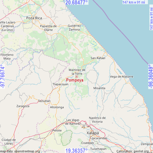
Pompeya GPS coordinates[2]
20° 1' 32.016" North, 97° 3' 48.996" West
| Map corner | latitude | longitude |
|---|---|---|
| Upper-left | 20.68477°, | -97.76674° |
| Center: | 20.02556°, | -97.06361° |
| Lower-right: | 19.36357°, | -96.36049° |
| Map W x H: | 146.9×146.9 km | = 91.3×91.3mi |
| max Lat: | 32.7° ⇑42.5% North |
| Pompeya: | 20.02556° |
| min Lat: | ⇓57.5% South 14.53588° |
| min Long | Pompeya | max Long |
| -117.105° | -97.06361° | -86.73105° |
| W 74%⇐ | ⇒26% E |
Elevation
Elevation of Pompeya is 128 m = 420 ft, and this is 1125.7 m = 3693 ft below average elevation for this country.
| Max E: |
3497 m = 11473 ft | 78.1% |
| Avg. | 1253.7 m = 4113 ft | |
| Pompeya | 128 m = 420 ft | |
Min E: |
-1 m = -3 ft | 21.9% |
See also: Mexico elevation on elevation.city.
Geographical zone
Pompeya is located in North Torrid zone (between Equator and Tropic of Cancer). Distance of this Northern Tropic circle is 379.3 km =235.7 mi to North.| Distance of | km | miles | from Pompeya |
|---|---|---|---|
| North Pole | 7780.4 | 4834.5 | to North |
| Arctic Circle | 5174.5 | 3215.3 | to North |
| Tropic Cancer | 379.3 | 235.7 | to North |
| Equator | 2226.6 | 1383.5 | to South |


Nearby cities:
15 places around Pompeya: (largest is in red/bold)
• Almanza
6.7 km =4.2 mi,  159°
159°
• Colonias Pedernales
2.6 km =1.6 mi,  29°
29°
• Ixtacuaco
4.3 km =2.7 mi,  318°
318°
• Javier Rojo Gómez (Novara)
3.2 km =2 mi,  270°
270°
• La Colmena
8.8 km =5.5 mi,  46°
46°
• La Palmilla
8.6 km =5.3 mi, 266°
• La Reforma
7.8 km =4.8 mi,  314°
314°
• Luis Echeverría
4.9 km =3 mi, 319°
• Martínez de la Torre
5 km =3.1 mi,  3°
3°
• Pahua Hueca
7.2 km =4.5 mi,  172°
172°
• Plan de Limón
8.5 km =5.3 mi,  69°
69°
• Pueblo Viejo Dos
5.6 km =3.5 mi, 53°
• San Pedro Tlapacoyan
5.1 km =3.2 mi, 314°
• Villa Independencia
3.5 km =2.2 mi,  19°
19°
• Villanueva
9.1 km =5.7 mi, 34°
Sources, notices
• [Note1] Compared only with cities in Mexico existing in our database
• [Src1] Map data: © OpenStreetMap contributors (CC-BY-SA)
• [Src2] Other city data from geonames.org with taken over terms of usage.
• [Src3] Geographical zone / Annual Mean Temperature by Robert A. Rohde @ Wikipedia
