La Reforma geodata
La Reforma (Veracruz) is a populated place; located in Mexico in America/Mexico_City (GMT-6) time zone. With population of 520 people, there are 16208 cities with bigger population in this country. Compared to other cities in Mexico, 58.6% of cities are located further ↓South; 73.4% of cities are located further ←West and 78.7% of cities have higher elevation than La Reforma. Note1


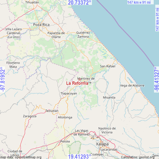
La Reforma GPS coordinates[2]
20° 4' 28.992" North, 97° 6' 59.004" West
| Map corner | latitude | longitude |
|---|---|---|
| Upper-left | 20.73372°, | -97.81952° |
| Center: | 20.07472°, | -97.11639° |
| Lower-right: | 19.41293°, | -96.41327° |
| Map W x H: | 146.9×146.9 km | = 91.3×91.3mi |
| max Lat: | 32.7° ⇑41.4% North |
| La Reforma: | 20.07472° |
| min Lat: | ⇓58.6% South 14.53588° |
| min Long | La Reforma | max Long |
| -117.105° | -97.11639° | -86.73105° |
| W 73.4%⇐ | ⇒26.6% E |
Elevation
Elevation of La Reforma is 117 m = 384 ft, and this is 1136.7 m = 3729 ft below average elevation for this country.
| Max E: |
3497 m = 11473 ft | 78.7% |
| Avg. | 1253.7 m = 4113 ft | |
| La Reforma | 117 m = 384 ft | |
Min E: |
-1 m = -3 ft | 21.3% |
See also: Mexico elevation on elevation.city.
Geographical zone
La Reforma is located in North Torrid zone (between Equator and Tropic of Cancer). Distance of this Northern Tropic circle is 373.8 km =232.3 mi to North.| Distance of | km | miles | from La Reforma |
|---|---|---|---|
| North Pole | 7775 | 4831.2 | to North |
| Arctic Circle | 5169.1 | 3211.9 | to North |
| Tropic Cancer | 373.8 | 232.3 | to North |
| Equator | 2232.1 | 1387 | to South |


Nearby cities:
15 places around La Reforma: (largest is in red/bold)
• Arroyo del Potrero
9.5 km =5.9 mi,  34°
34°
• Colonias Pedernales
7.5 km =4.7 mi,  115°
115°
• El Jobo
8.4 km =5.2 mi,  216°
216°
• Huipiltepec
10.6 km =6.6 mi,  1°
1°
• Ixtacuaco
3.5 km =2.2 mi,  130°
130°
• Javier Rojo Gómez (Novara)
5.9 km =3.7 mi,  156°
156°
• Jiliapan
7.7 km =4.8 mi,  271°
271°
• La Palmilla
6.8 km =4.2 mi,  206°
206°
• Luis Echeverría
2.9 km =1.8 mi, 126°
• Martínez de la Torre
5.8 km =3.6 mi,  94°
94°
• Pompeya
7.8 km =4.8 mi, 134°
• Pueblo Viejo Dos
10.2 km =6.3 mi,  101°
101°
• San Pedro Tlapacoyan
2.6 km =1.6 mi, 134°
• Villa Independencia
7.1 km =4.4 mi,  107°
107°
• Villanueva
10.9 km =6.8 mi,  79°
79°
Sources, notices
• [Note1] Compared only with cities in Mexico existing in our database
• [Src1] Map data: © OpenStreetMap contributors (CC-BY-SA)
• [Src2] Other city data from geonames.org with taken over terms of usage.
• [Src3] Geographical zone / Annual Mean Temperature by Robert A. Rohde @ Wikipedia
