Guadalupe Villa Cárdenas geodata
Guadalupe Villa Cárdenas (Guanajuato) is a populated place; located in Mexico in America/Mexico_City (GMT-6) time zone. With population of 931 people, there are 9365 cities with bigger population in this country. Compared to other cities in Mexico, 73.8% of cities are located further ↓South; 76.1% of cities are located further →East and 62.1% of cities have lower elevation than Guadalupe Villa Cárdenas. Note1
Current local time in Guadalupe Villa Cárdenas:
12:32 PM, MondayDifference from your time zone: hours


Guadalupe Villa Cárdenas GPS coordinates[2]
20° 50' 6" North, 101° 21' 2.016" West
| Map corner | latitude | longitude |
|---|---|---|
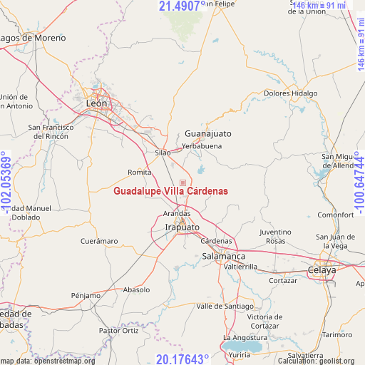
| Upper-left | 21.4907°, | -102.05369° |
| Center: | 20.835°, | -101.35056° |
| Lower-right: | 20.17643°, | -100.64744° |
| Map W x H: | 146.1×146.1 km | = 90.8×90.8mi |
| max Lat: | 32.7° ⇑26.2% North |
| Guadalupe Villa Cárdenas: | 20.835° |
| min Lat: | ⇓73.8% South 14.53588° |
| min Long | Guadalupe Villa | max Long |
| -117.105° | -101.35056° | -86.73105° |
| W 23.9%⇐ | ⇒76.1% E |
Elevation
Elevation of Guadalupe Villa Cárdenas is 1761 m = 5778 ft, and this is 507.3 m = 1664 ft above average elevation for this country.
| Max E: |
3497 m = 11473 ft | 37.9% |
| Guadalupe Villa Cárdenas | 1761 m 5778 ft | |
| Avg. | 1253.7 m = 4113 ft | |
Min E: |
-1 m = -3 ft | 62.1% |
See also: Mexico elevation on elevation.city.
Geographical zone
Guadalupe Villa Cárdenas is located in North Torrid zone (between Equator and Tropic of Cancer). Distance of this Northern Tropic circle is 289.3 km =179.8 mi to North.| Distance of | km | miles | from Guadalupe Villa Cárdenas |
|---|---|---|---|
| North Pole | 7690.4 | 4778.6 | to North |
| Arctic Circle | 5084.5 | 3159.4 | to North |
| Tropic Cancer | 289.3 | 179.8 | to North |
| Equator | 2316.6 | 1439.5 | to South |


Nearby cities:
15 places around Guadalupe Villa Cárdenas: (largest is in red/bold)
• Aldama
4.3 km =2.7 mi,  118°
118°
• El Espejo
6.2 km =3.9 mi,  351°
351°
• Hacienda Guadalupe
2.5 km =1.6 mi,  77°
77°
• Hacienda de Márquez
6.1 km =3.8 mi,  188°
188°
• La Calaverna
5.8 km =3.6 mi, 347°
• La Calera
4.2 km =2.6 mi,  152°
152°
• Los Nicolases
4.3 km =2.7 mi,  53°
53°
• Medio Sitio
3.9 km =2.4 mi, 350°
• Molino de Santa Ana
0.7 km =0.4 mi,  169°
169°
• Purísima del Progreso
5.1 km =3.2 mi,  155°
155°
• Rancho Nuevo del Llanito
2.3 km =1.4 mi,  235°
235°
• San Andrés de la Baraña
5 km =3.1 mi,  5°
5°
• San Antonio el Rico
2.6 km =1.6 mi, 238°
• San José de Llanos
4.9 km =3 mi,  61°
61°
• San Vicente
1.2 km =0.7 mi,  126°
126°
Sources, notices
• [Note1] Compared only with cities in Mexico existing in our database
• [Src1] Map data: © OpenStreetMap contributors (CC-BY-SA)
• [Src2] Other city data from geonames.org with taken over terms of usage.
• [Src3] Geographical zone / Annual Mean Temperature by Robert A. Rohde @ Wikipedia
